Driving the Cabot Trail in a single day is achievable without feeling rushed, but it requires a strategy of logistical sequencing, not just speed.
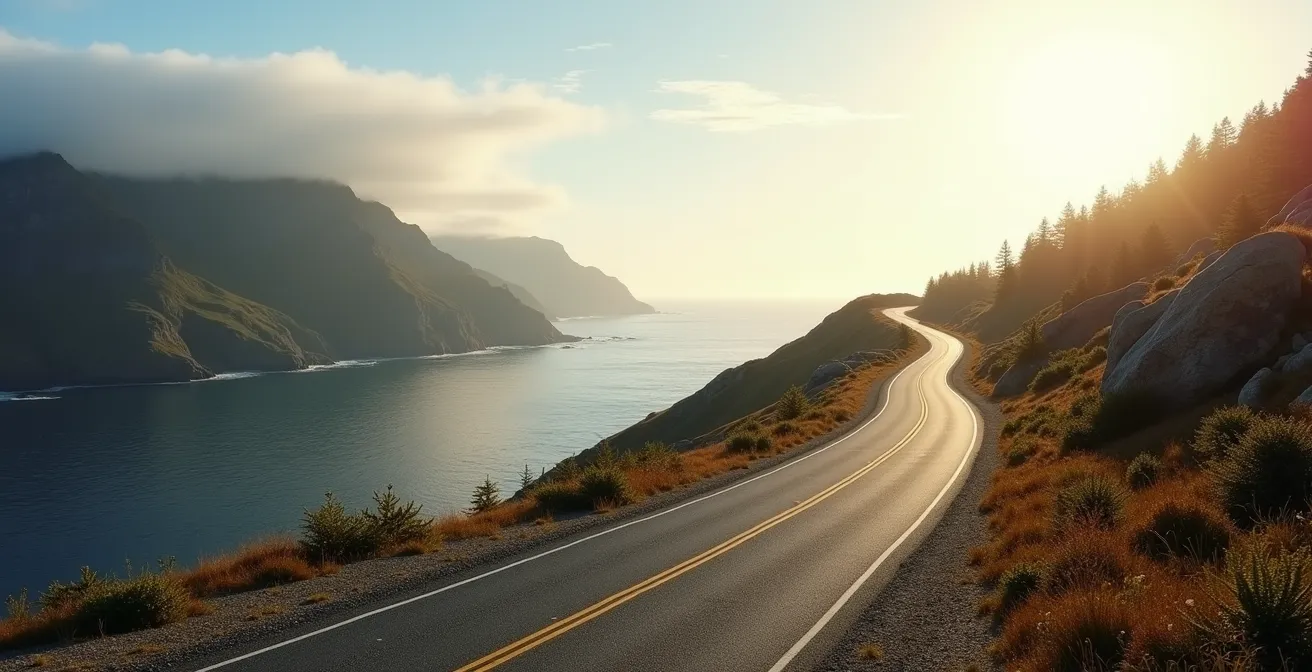
- Direction Matters: A counter-clockwise route minimizes motion sickness and aligns you perfectly for optimal sunset photography on the west coast.
- Logistical Anchors are Key: Your last reliable fuel is in Chéticamp or Ingonish; planning around these stops is non-negotiable.
Recommendation: Plan your day by reverse-engineering from your primary scenic goal, like the sunset at Skyline Trail, rather than just starting at dawn.
The desire to conquer Nova Scotia’s legendary Cabot Trail in a single day presents a classic traveller’s paradox: how to experience one of the world’s most scenic drives without it becoming a rushed, stressful blur? Many guides offer the standard advice—start early, pack snacks, drive counter-clockwise. While well-intentioned, this advice often fails to address the core anxiety of a time-limited tourist: the fear of missing out. You worry about arriving at a famous lookout only to find the parking lot full, or reaching the dramatic western cliffs after the golden light has faded.
The common trap is treating the Cabot Trail as a single, 300-kilometre road to be checked off a list. This approach invariably leads to frustration. But what if the secret wasn’t about driving faster, but about planning smarter? What if the key was a shift in mindset from covering distance to unlocking a series of perfectly timed experiences? This is the essence of strategic sequencing, a methodology used by professional tour schedulers to maximize scenic rewards while minimizing logistical friction.
This guide abandons the generic “start early” mantra. Instead, it provides a framework for making the critical decisions that define your day. We will treat the Trail not as a road, but as a system of opportunities governed by light, traffic flow, and essential services. We’ll delve into the tactical choices around parking, driving direction, fuel stops, and seasonal timing. By understanding the “why” behind each decision, you can build a personalized, one-day itinerary that feels expansive and unhurried, ensuring you capture the highlights without the pressure.
This article breaks down the essential logistical anchors of your one-day journey. The following sections will guide you through the key strategic decisions, from parking tactics at peak hours to catching the perfect sunset light, allowing you to craft a seamless and spectacular Cabot Trail experience.
Summary: Your One-Day Cabot Trail Strategic Itinerary
- The Parking Strategy for the Top of Ingonish Beach at Midday?
- Which Side of the Trail Offers the Best Western Light for Photography?
- Clockwise or Counter-Clockwise: Which Direction Minimizes Car Sickness?
- When is the Last Reliable Gas Station Before the Northern Loop Section?
- What Date Do They Officially Close the Cabot Trail for Winter Snow?
- When to Drive the Cabot Trail to Catch the Best Sunset Light?
- Why You Must Fill Your Tank in Gander Before Heading to Fogo Island?
- How to Photograph the Famous Red Chairs Without Waiting in Line for an Hour?
The Parking Strategy for the Top of Ingonish Beach at Midday?
Arriving at the stunning Ingonish Beach between 11 AM and 2 PM can quickly turn a scenic stop into a frustrating search for parking. This peak congestion window is a major bottleneck for one-day itineraries. A successful visit doesn’t depend on luck, but on a pre-planned parking strategy. Your primary goal is to avoid the main beach lot entirely during these hours. Instead, think of the surrounding area as a network of alternatives. The Broad Cove Campground parking area, for instance, offers direct beach access and often has more availability than the primary lot.
If both primary and campground lots are full, your best backup is the overflow area near the Keltic Lodge’s golf course. It’s a pleasant, five-minute walk down to the beach and is frequently overlooked by visitors focused on the main entrance. Another effective strategy is to use nearby attractions as a strategic buffer. As an example, the Cape Smokey Gondola facility offers ample parking just a short drive away. Visitors can enjoy the gondola and its spectacular views, then drive down to Ingonish Beach after 3 PM when the crowds have thinned. This turns a potential parking headache into another scenic highlight.
Ultimately, the most effective approach is proactive planning. By accepting that the main lot is a high-risk gamble at midday, you can build a more resilient itinerary. Having a sequence of options ready—from campground lots to nearby attractions—ensures your schedule remains on track and your experience stays positive.
Your Action Plan: Peak-Hour Parking at Ingonish
- Check Parks Canada’s online trail closure status before 10 AM to gauge overall park congestion levels.
- Target the Broad Cove Campground parking area as your primary option; it offers beach access with typically more availability.
- If main lots are full, use the Keltic Lodge overflow area near the golf course, which is just a 5-minute walk to the beach.
- Arrive either before 10 AM or after 3 PM to avoid the 11 AM-2 PM peak congestion window.
- Have a backup plan ready: nearby Warren Lake or Freshwater Lake offer similar experiences with easier parking.
Which Side of the Trail Offers the Best Western Light for Photography?
For photographers, a one-day trip on the Cabot Trail is an exercise in “light-chasing.” The direction of the sun dictates where you need to be and when. The unequivocal answer for the best afternoon and evening light is the western side of the Trail, from the French Mountain area down to Chéticamp. This coastline directly faces the setting sun over the Gulf of St. Lawrence, creating the dramatic side-lighting and long, sweeping shadows that define classic Cape Breton photography. Trying to shoot on the eastern (Ingonish) side in the afternoon results in backlit mountains and flat, uninteresting light on the coastal features.
The prime time, or “golden hour,” on the western coast typically occurs between 3 PM and 6 PM, depending on the season. This is when the low sun bathes the highland cliffs in warm, golden light. To capitalize on this, your one-day schedule must be reverse-engineered from this window. It means you need to have completed the northern loop and be arriving at the French Mountain and Skyline Trail lookouts by mid-afternoon. The western side also boasts a superior “blue hour,” the period of soft, cool light just after sunset, which creates a serene afterglow on the Gulf waters.
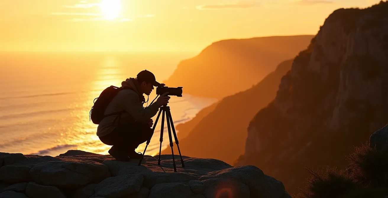
As this image illustrates, the composition of a great shot on this side of the trail involves capturing the interplay between the cliffs, the sea, and that magical western light. Planning your day to be in this exact location during this specific time window is the cornerstone of successful one-day Cabot Trail photography. The following table from Parks Canada’s sightseeing guide breaks down the fundamental differences.
| Aspect | Western Side (Chéticamp) | Eastern Side (Ingonish) |
|---|---|---|
| Golden Hour Quality | Direct sunset light on cliffs (3-6 PM) | Sunrise light only (6-8 AM) |
| Blue Hour Advantage | Soft afterglow on Gulf of St. Lawrence | Pre-dawn blues over Atlantic |
| Shadow Drama | Long sweeping shadows across highlands | Backlit mountain silhouettes |
| Best Viewpoints | French Mountain to Le Buttereau trail area | Cape Smokey to Middle Head |
| Optimal Timing | Arrive by 3 PM for setup | Must start before 6 AM |
Clockwise or Counter-Clockwise: Which Direction Minimizes Car Sickness?
The debate over driving direction on the Cabot Trail often centers on views, but for many passengers, the primary concern is comfort. The tight curves and steep grades can be a challenge for anyone prone to motion sickness. From a scheduling and comfort perspective, the counter-clockwise direction is superior for minimizing car sickness. The main reason is that this route tackles the two most dramatic climbs, Cape Smokey and North Mountain, as ascents rather than steep, winding descents. Going uphill is generally easier on the inner ear and provides a greater sense of control for the driver.
Furthermore, the counter-clockwise route places the passenger on the landward side of the vehicle for the majority of the drive. This provides stable, nearby reference points (the rock faces and forest) for the eyes, which helps the brain reconcile the body’s sense of motion. In the clockwise direction, the passenger is on the ocean side, looking out at a vast, distant horizon with dramatic drop-offs, a combination that can easily induce vertigo and nausea. According to Cabot Trail tourism data, the counter-clockwise direction is chosen by 65% of drivers who express concern for passenger comfort.
To further mitigate the risk of motion sickness, a few proactive steps are essential:
- Pre-Trip Preparation: Stop at a Shoppers Drug Mart in a larger town like Sydney or Baddeck for Gravol (Dimenhydrinate), Canada’s leading motion sickness medication.
- Strategic Breaks: Plan mandatory 15-minute recovery stops at key points like Pleasant Bay and the village of Chéticamp. This allows everyone to get fresh air and reset their equilibrium.
- Driving Technique: The driver should focus on maintaining a steady, consistent speed through curves, avoiding the sudden acceleration and braking that exacerbates motion sickness on the steep 12% grade sections.
When is the Last Reliable Gas Station Before the Northern Loop Section?
On a one-day Cabot Trail trip, fuel is not just a commodity; it’s a critical logistical anchor. Running out of gas in the remote northern section of Cape Breton Highlands National Park is a trip-ending mistake. Therefore, you must operate with a simple, unbreakable rule: the Irving in Chéticamp (if driving counter-clockwise) or the Ultramar in Ingonish (if driving clockwise) are your last 100% reliable fuel stops before entering the most isolated part of the trail. Do not proceed past these points without a full tank.
While maps may show small, independent gas pumps in locations like Cape North or a co-op in Pleasant Bay, their operation is often seasonal and their hours can be highly irregular. An incident in October 2023 saw the independent pump in Cape North close unexpectedly for a week, stranding several unprepared drivers. These smaller stations should be considered emergency options only, not part of your primary plan. This is especially true for those driving electric vehicles; while Parks Canada has installed six charging stations within the park, planning your route between the reliable Level 3 chargers in major towns is essential.
Treating Chéticamp and Ingonish as your non-negotiable fueling bookends simplifies your entire schedule. It removes the stress of “range anxiety” and allows you to focus purely on the scenery of the northern loop. The following table clarifies the difference between the reliable and unreliable options.
| Location | Station Type | Hours | Distance to Northern Loop | Services |
|---|---|---|---|---|
| Chéticamp Irving | Major Chain | 6 AM – 11 PM (Summer) | 0 km (Loop entrance) | Gas, Diesel, Convenience Store |
| Ingonish Ultramar | Major Chain | 24/7 (May-Oct) | 0 km (Loop entrance) | Gas, Diesel, EV Level 3 |
| Cape North Independent | Private | Irregular/Seasonal | Mid-loop | Gas only (Unreliable) |
| Pleasant Bay Co-op | Co-op | 8 AM – 6 PM | Western mid-point | Gas, Limited supplies |
What Date Do They Officially Close the Cabot Trail for Winter Snow?
While the Cabot Trail road itself technically remains open year-round, weather permitting, a one-day trip as described in this guide is only feasible during the main operational season. For all practical purposes, the functional “closure” of the Trail for tourists happens when Parks Canada shuts down its facilities and services. This creates a critical window that travelers must respect.
According to Parks Canada, their full services are only guaranteed between the Victoria Day weekend in May and the Canadian Thanksgiving weekend in October. After Thanksgiving Monday (the second Monday in October), visitor centres close, washrooms are locked, and most importantly, park maintenance and emergency response are significantly reduced. A sudden snowstorm, which can happen as early as late October on the highlands, could leave you stranded with no support. Therefore, for a safe and predictable one-day itinerary, you must plan your trip within this May-to-October window. Data from Parks Canada confirms that all Cabot Trail facilities and services are officially closed from October 14th (Canadian Thanksgiving) through Victoria Day weekend in May, making travel during this period unpredictable and not recommended for a tight schedule.
If you are considering a drive in the shoulder seasons (late May or early October), it’s imperative to monitor conditions actively. Cell service is intermittent throughout the park, so relying on real-time data once you’re on the trail is not an option. Your pre-departure checklist should include:
- Checking the official NS 511 website for any road condition warnings or closures.
- Monitoring detailed Cape Breton forecasts from a reliable source like The Weather Network.
- Calling the Parks Canada information line (902-224-2306) directly for the most current status of trails and lookouts.
- Downloading offline maps of the entire region before you depart from Baddeck or Sydney.
When to Drive the Cabot Trail to Catch the Best Sunset Light?
Catching a spectacular sunset over the Gulf of St. Lawrence is the crowning achievement of a one-day Cabot Trail journey. This isn’t an event you leave to chance; it’s the anchor point from which your entire afternoon schedule should be reverse-engineered. The prime location for this experience is undeniably the Skyline Trail and the series of lookouts on French Mountain that precede it. The key is to time your arrival not for the sunset itself, but for the “golden hour” that precedes it, giving you ample time to hike, set up, and enjoy the changing light.
A professional photographer’s case study highlights this strategy perfectly. By starting a counter-clockwise drive around 10 AM from Ingonish, they positioned themselves at the Skyline Trailhead by 4 PM. This allowed them to complete the 4-mile (6.5 km) out-and-back hike to the cliff edge well before the best light. As an analysis of the Skyline Trail sunset experience shows, taking cameras for sunset not only results in better views but also less crowded conditions. Visitors planning this must account for the hike and bring flashlights for the return journey in the dark.
To execute this, you must work backwards from the sunset time. In summer, the sun might set around 7:30 PM in Chéticamp. Your “golden hour” window is roughly 5:30 PM to 7:30 PM. To be at the Skyline Trail lookout during this period, you need to start the hike no later than 4:30 PM. This means you must have completed the entire northern loop and be arriving in the French Mountain area by 4:00 PM at the latest. This calculation dictates your departure time from Ingonish and the number of stops you can make along the northern coast, demonstrating the power of strategic sequencing.
Why You Must Fill Your Tank in Gander Before Heading to Fogo Island?
In the lexicon of Canadian road trips, there’s a well-known principle called the “Gander Rule.” It originates from the journey to another iconic, remote Atlantic Canada destination: Fogo Island, Newfoundland. The rule is simple: Gander is the last major hub with comprehensive services—gas, ATMs, pharmacies, major grocery stores—before you begin the long drive and ferry ride to the island. To leave Gander without a full tank of gas and all necessary supplies is to risk being stranded. This principle of identifying and respecting your last logistical anchor is not just for Newfoundland; it’s the perfect analogy for planning a successful Cabot Trail trip.
Just as Gander serves Fogo Island, the towns of Baddeck and Sydney serve as the “Gander” for the Cabot Trail. Before you even start the Trail, these are your final opportunities to prepare for the remote sections ahead. This is where you fill your gas tank completely, withdraw cash from a reliable bank ATM for the small, cash-only craft shops you’ll encounter, and stock up on water and snacks at a large grocery store like an Atlantic Superstore. Food options within the National Park are limited and expensive; being self-sufficient gives you flexibility.
This comparative table of remote Canadian destinations illustrates why this rule is so universal. The distance and lack of services between the last major hub and the remote area create a high-stakes scenario. Applying the “Gander Rule” to the Cabot Trail means treating Baddeck or Sydney as your final, non-negotiable preparation point. Once you pass them, your focus should be entirely on the drive, not on finding basic supplies.
| Destination | Last Major Hub | Distance to Remote Area | Critical Services |
|---|---|---|---|
| Fogo Island, NL | Gander | 100 km + ferry | Gas, ATM, Pharmacy, Groceries |
| Cabot Trail North | Baddeck/Sydney | 75-100 km | Gas, ATM, Canadian Tire, Pharmacy |
| Dempster Highway, YT | Dawson City | 40 km to start | Gas, Supplies, Repairs |
| James Bay Road, QC | Matagami | 0 km (gateway) | Full services before 620 km stretch |
Key Takeaways
- Strategic Sequencing: A successful one-day trip relies on planning around logistical anchors (fuel, sunset) rather than just driving from point A to B.
- Counter-Clockwise is King: This direction offers better passenger comfort by tackling steep grades uphill and provides optimal positioning for afternoon sunset photography on the western coast.
- Logistical Anchors are Non-Negotiable: Treat Chéticamp and Ingonish as your final reliable fuel stops, and use Baddeck/Sydney to stock up on all cash and supplies before starting the Trail.
How to Photograph the Famous Red Chairs Without Waiting in Line for an Hour?
The iconic Parks Canada red chairs are a must-have photo for many visitors, but at popular locations like the Skyline Trail, this can mean waiting in a long, frustrating queue, especially at midday. The key to getting this shot without sacrificing an hour of your tight one-day schedule is to understand two things: peak congestion times and the existence of alternative, lesser-known chair locations.
First, the crowds are predictable. According to Parks Canada data, the hours between 10 AM to 4 PM see 90% of daily visitors at top-tier sites like the Skyline Trail. Attempting to get your red chair photo here during this window is a strategic error on a one-day trip. The solution is not to skip the photo, but to get it elsewhere. Parks Canada has placed these chairs throughout their national parks system, and several stunning, low-traffic locations exist right on the Cabot Trail.
The most effective strategy is to seek out the identical red chairs at the Mary Ann Falls lookout or the Broad Cove Beach lookout. These spots offer breathtaking scenery that is quintessentially Cape Breton, but they see a fraction of the foot traffic of the Skyline Trail. You can often have the chairs entirely to yourself, allowing for a relaxed photo session that takes minutes, not hours. By building one of these alternative locations into your itinerary, you secure the iconic photo while cleverly sidestepping the biggest bottleneck on the Trail. It’s a perfect example of how local knowledge and strategic planning can save precious time and enhance the overall experience.
With this strategic framework, you are now equipped to build your own perfect one-day Cabot Trail itinerary. Use this guide to make informed decisions that transform a rushed drive into a seamless series of unforgettable scenic moments. Plan your logistical anchors, reverse-engineer your schedule from the sunset, and enjoy every minute of your spectacular journey.