Mastering Vancouver’s outdoors isn’t about gear; it’s about exploiting temporal and spatial loopholes the tourists don’t know.
- Beat crowds by operating outside peak hours, like before 9 AM or during the city-wide “dinner rush” window.
- Use specific geographic positions for superior experiences, such as Jericho Beach for photos or Queen Elizabeth Park for reconnaissance.
- Treat safety not as a rulebook to be read, but as a mandatory skill to be mastered, especially concerning cold water and vessel traffic.
Recommendation: Adopt a “temporal hacking” and “navigational intelligence” mindset to transform every urban outing from a generic activity into a strategic win.
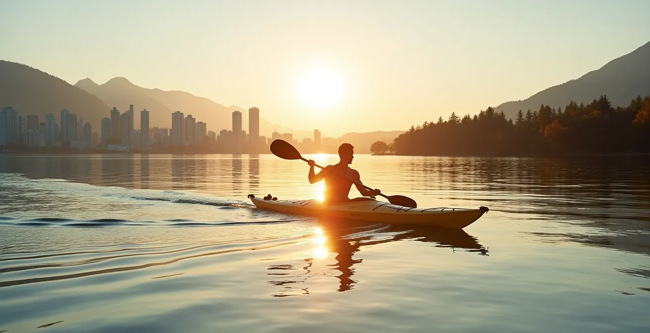
The question isn’t just about speed. Paddling from Coal Harbour to Siwash Rock in under two hours is a benchmark, a test of efficiency against the backdrop of one of the world’s most stunning urban coastlines. For the active Vancouverite, the city’s waterways aren’t just for sightseeing; they are a liquid gym, a transit corridor, and a personal escape route. But moving with purpose through this environment requires more than just paddle strength. It demands a higher level of awareness—a form of navigational intelligence.
Most guides will tell you to rent a kayak, check the weather, and watch for boats. This is basic advice for a passive tourist experience. It does little to prepare you for the complex dance of currents in Burrard Inlet, the relentless ferry traffic, or the crowds that clog every popular access point. The standard approach leaves you reacting to the city’s rhythm, constantly battling for space and time. This guide is built on a different premise: that you can and should dictate your own terms by understanding and exploiting the city’s hidden operational patterns.
The real key to mastering Vancouver’s land and seascapes is to move beyond generic advice and adopt the mindset of an urban strategist. It’s about knowing *why* a specific beach offers better light for photography, *when* the fishing fleet creates a temporary obstacle course in False Creek, and *how* to use the city’s own infrastructure to your advantage. This isn’t just about kayaking faster; it’s about a smarter, more fulfilling engagement with the entire ecosystem.
To cultivate this mindset, we will explore a series of hyper-specific challenges and solutions that only a local would encounter. This guide dissects the very fabric of Vancouver’s recreational life, providing the tactical knowledge needed to turn every outing into an optimized, high-performance experience. From water to asphalt, you’ll learn to see the city not as a series of destinations, but as a dynamic circuit to be navigated with skill.
Summary: A Waterman’s Guide to Navigating Vancouver
- What Are the Speed Limits for Kayaks Near the North Shore Ferries?
- Why Sunset Photos of the North Shore Mountains are Better from Jericho Beach than English Bay?
- How to Cycle the Seawall Without Constantly Stopping for Sightseers?
- When Does the Fishing Fleet Arrive at Granville Island Market in the Morning?
- How to Visit a Public Observation Deck in Vancouver Without Paying $40?
- Why Parking at Shannon Falls is Easier on a Tuesday Than a Saturday?
- Why a Wet Exit Skill is Mandatory Before Kayaking in Orca Waters?
- How to Avoid Vancouver Traffic When Driving the Sea-to-Sky Highway to Whistler?
What Are the Speed Limits for Kayaks Near the North Shore Ferries?
There is no specific “speed limit” for a non-powered craft like a kayak, but this is a dangerously misleading fact. The real issue is not your speed, but the strict navigational rules governing all vessels in the high-traffic shipping lanes of Burrard Inlet. The primary hazard is the SeaBus, a marine workhorse that operates with relentless frequency. According to TransLink’s official schedule, these ferries cross the inlet every 15 minutes during the day, creating a constant, fast-moving obstacle. Your responsibility as a paddler is not to race them, but to stay completely out of their designated path.
The Port of Vancouver is the ultimate authority here, and their guidelines are absolute. The official safe boating guide for Burrard Inlet establishes several key rules for small craft. Most importantly, kayakers must stay to the right-hand side of any channel and are strictly forbidden from crossing in front of deep-sea vessels or ferries. The area is a patchwork of speed-restricted zones (typically 5 knots) that apply to motorized vessels, but these zones signal areas of high congestion and caution for everyone.
Furthermore, specific security zones exist, such as the area around Canada Place, where all unauthorized vessels must maintain a distance of at least 50 metres. For a kayaker, the mindset must shift from “How fast can I go?” to “Where am I forbidden to be?” Your route must be planned to completely avoid the ferry lanes and commercial anchorages. Think of the inlet not as an open playground, but as a system of highways and intersections where you are the most vulnerable user. Your survival depends on defensive positioning and yielding right-of-way 100% of the time.
Why Sunset Photos of the North Shore Mountains are Better from Jericho Beach than English Bay?
The answer lies in the fundamental physics of light and geography. From the popular shores of English Bay, you are looking almost directly north at the mountains. As the sun sets in the west (to your left), the mountains are backlit, plunging their detailed faces into shadow. This results in the classic, but often flat, silhouette photograph. While dramatic, it erases all the texture, ridgelines, and forest detail that make the North Shore range so spectacular.
To capture the mountains in their full glory, you need to change your angle of attack. By paddling west to Jericho Beach, you reposition yourself so that the setting sun is now providing strong side-lighting across the mountain faces. This glancing light, especially during the ‘golden hour’ just before sunset, illuminates every peak and valley, creating depth, texture, and the coveted pinkish-orange hue known as alpenglow. You are no longer shooting a shadow; you are shooting a fully lit subject.
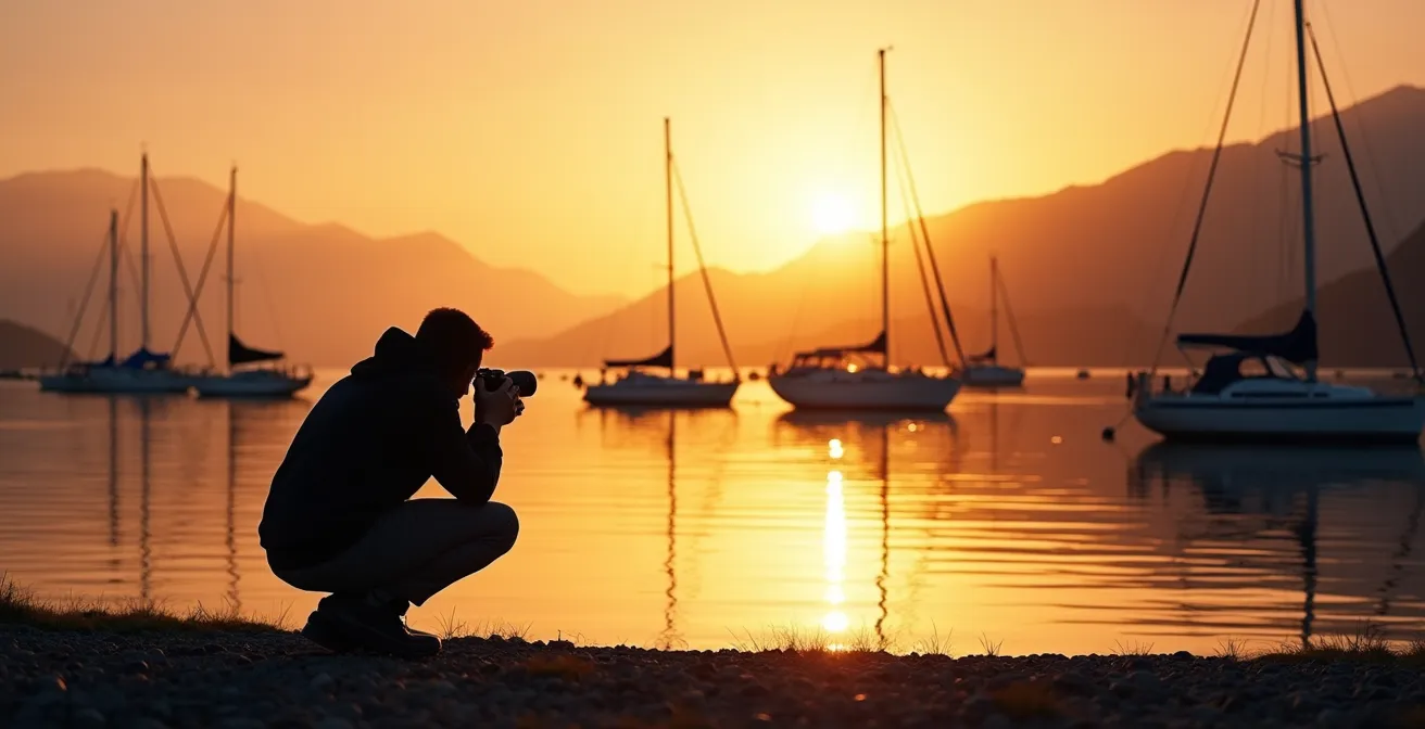
As the illustration shows, the western position of Jericho Beach is key. The area near the Royal Vancouver Yacht Club is particularly strategic. From here, the anchored sailboats provide perfect foreground elements. Their vertical masts create powerful compositional lines that contrast with the horizontal sweep of the mountains, adding a sense of scale and layered depth to your shot. From English Bay, these boats are often part of a cluttered middle ground, but from Jericho, they become a deliberate artistic choice. An evening paddle to Jericho is not just a workout; it’s a strategic photographic mission.
How to Cycle the Seawall Without Constantly Stopping for Sightseers?
The Stanley Park Seawall is a victim of its own success. To navigate it efficiently, you must treat it less like a scenic path and more like a congested highway, employing strategies of timing and route selection. First, you must obey the cardinal rule: the entire 9-kilometer loop has a mandatory counter-clockwise one-way cycling rule. Attempting to go against this flow is not only dangerous but will lead to constant, frustrating confrontations.
The real secret is “temporal hacking.” The Seawall is predictably empty during two key windows. The first is the pre-9 AM ‘Golden Hour’. Early morning riders are rewarded with cool air, minimal pedestrian traffic, and the best light. The second, more counter-intuitive window is the ‘Dinner Rush’ between 6 PM and 8 PM. As the majority of tourists flock to restaurants in the West End and Gastown, the Seawall experiences a significant dip in traffic, offering a brief window for an uninterrupted ride.
For those moments when you must ride during peak hours, knowing the bypass is essential. The stretch between Brockton Point and the Lions Gate Bridge is a notorious bottleneck. Locals know to use the parallel bike path along Stanley Park Drive as an ‘express lane’ to bypass this congestion. Finally, master the local bell etiquette. A single, polite ‘ding’ given well in advance is a signal of approach and awareness, not an aggressive demand to move. It’s a subtle part of the social contract that keeps traffic flowing smoothly among those in the know.
When Does the Fishing Fleet Arrive at Granville Island Market in the Morning?
To witness the authentic core of Granville Island’s market, you need to align your schedule with the fishing fleet, not the tourists. The prime window to see commercial fishing boats unloading their catch at Fishermen’s Wharf is between 6:00 AM and 8:00 AM. This is when the island is at its most real, smelling of salt and diesel, with crews working to get fresh seafood to the market stalls before the first customers arrive.
The intensity of this activity is seasonal. While the general peak for vessel traffic in False Creek is from April to October, certain periods are electric. Activity explodes during the short but legendary Spot Prawn season in May, and again during the various salmon runs throughout the summer and fall. During these times, the 6-8 AM window is a flurry of organized chaos that is a spectacle in itself.
For a kayaker, this period presents both an opportunity and a challenge. To observe the action safely, you must be a respectful and cautious visitor. Launching from the False Creek Community Centre wharf provides direct access, but it’s crucial to stay out of the main commercial channel. The tactical move is to hug the southern shore of False Creek as you paddle, giving the working vessels a wide berth. Never approach a boat that is actively unloading. Your goal is to be an invisible observer, appreciating the vital commercial lifeblood of the island before it transforms into a visitor attraction for the day.
How to Visit a Public Observation Deck in Vancouver Without Paying $40?
For an active Vancouverite, a high vantage point isn’t just for sightseeing; it’s a critical tool for pre-trip reconnaissance. Paying a premium for a tourist tower is unnecessary when the city offers superior, free alternatives that serve a practical purpose. The ultimate free viewpoint is at Queen Elizabeth Park, which, at 167 meters above sea level, is the highest geographical point in the city of Vancouver. It offers a breathtaking, unobstructed panorama of the downtown skyline, English Bay, and the North Shore mountains.
Another fantastic urban option is the rooftop garden of the Vancouver Public Library’s central branch. Accessible and free during library hours, it provides a unique 360-degree perspective from within the heart of the downtown core. For a kayaker, these spots are invaluable. Before committing to a paddle, a quick trip to one of these locations allows you to visually inspect the real-time sea state in English Bay and Burrard Inlet. You can assess wind patterns by observing flags and water texture, check visibility, and get a tangible feel for the weather in a way no forecast can provide.
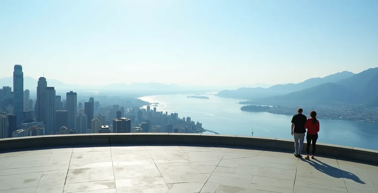
This strategy of using free public viewpoints for reconnaissance doubles as a fantastic, cost-free activity. It embodies the local’s mindset: using the city’s own infrastructure for a practical advantage. Instead of paying to be a passive observer, you are actively gathering intelligence for your next adventure, turning a simple view into a vital part of your planning process.
Why Parking at Shannon Falls is Easier on a Tuesday Than a Saturday?
The dramatic difference in parking difficulty between a Tuesday and a Saturday at Shannon Falls has little to do with the falls themselves and everything to do with visitor demographics. A Saturday crowd is an entirely different species from a Tuesday crowd, and understanding this is key to avoiding the notorious parking lot chaos on the Sea-to-Sky corridor.
On a weekend, you are competing with thousands of “weekend warriors” from across the Lower Mainland and Washington State, all on a similar schedule. As the data clearly shows, this creates an intense, concentrated rush. On a Saturday, the parking lot is often completely full by 10:30 AM. A Tuesday, however, is dominated by international tourists with flexible schedules and locals running errands. Their arrival times are distributed throughout the day, resulting in a constant but manageable flow. The lot rarely, if ever, reaches full capacity.
This comparative analysis highlights the strategic advantage of a weekday visit. The competition for resources is simply on a different scale.
| Day | Peak Arrival Time | Parking Full By | Visitor Demographics | Alternative Strategy |
|---|---|---|---|---|
| Saturday | 9:00 AM – 2:00 PM | 10:30 AM | Local weekenders, Fraser Valley tourists, Washington State visitors | Arrive after 4 PM for ‘post-hike exodus’ availability |
| Tuesday | Distributed throughout day | Rarely fills | International tourists with flexible schedules | Any time works, minimal competition |
For those forced into a weekend trip, the only viable strategies are extreme timing—arriving before 9 AM or waiting for the “post-hike exodus” after 4 PM. Otherwise, a Tuesday visit isn’t just easier; it’s a fundamentally different and more pleasant experience, transforming a potentially stressful parking hunt into a simple arrival.
Key Takeaways
- Temporal Hacking is Paramount: Your watch is your most important piece of gear. Operating before 9 AM or during the 6-8 PM dinner rush is the single most effective way to avoid crowds on water and land.
- Geography is Strategy: Your physical position dictates your experience. Choosing Jericho for light, Queen Elizabeth Park for reconnaissance, or the south shore of False Creek for safety are strategic choices, not just location preferences.
- Safety is an Active Skill, Not a Passive Rule: Regulations are the bare minimum. True safety in Vancouver’s waters comes from mastering skills like wet exits and developing an instinct for navigating cold water and commercial traffic.
Why a Wet Exit Skill is Mandatory Before Kayaking in Orca Waters?
The mandatory nature of a wet exit skill before paddling in waters frequented by orcas has almost nothing to do with the orcas themselves. This is the single most misunderstood aspect of kayaking in the Pacific Northwest. The danger isn’t the animal; it’s the environment the animal represents. As the experts at Deep Cove Kayak Centre put it in their Paddle Canada course guidelines:
The danger isn’t the orca, it’s the environment. Orca presence signifies you are in cold, open Pacific water, far from shore, where a capsize is a life-threatening event due to cold water shock and hypothermia, not animal interaction.
– Deep Cove Kayak Centre, Paddle Canada Certification Course Guidelines
The presence of orcas means you are in their territory: deep, open, and dangerously cold water. A capsize here is not an inconvenience; it is the start of a countdown to hypothermia. The initial, involuntary gasp reflex caused by sudden cold water immersion is a primary cause of drowning. A practiced wet exit is the first, non-negotiable step in a self-rescue sequence that you must execute flawlessly to survive. It’s the skill that allows you to remain calm, stay with your boat (your primary flotation device), and initiate a paddle float or re-entry and roll. Without it, panic is almost certain, and survival is unlikely. While Transport Canada regulations mandate maintaining a minimum 400-meter distance from killer whales, the real safety protocol is personal and skill-based.
Action Plan: Essential Wet Exit and Cold Water Training
- Enroll in Paddle Canada certified courses at a reputable local outfitter like Ecomarine Paddlesport Centres on Granville Island.
- Practice wet exit drills repeatedly at a place like Deep Cove Kayak Centre in controlled, sheltered conditions before attempting any open ocean paddling.
- Actively seek out cold water immersion training to learn how to manage and override the involuntary gasp reflex that poses an immediate drowning risk.
– Master self-rescue techniques, including paddle-float and re-enter-and-roll, in the calm waters of False Creek before testing them in the open Pacific. – Join guided training sessions that specifically simulate emergency exits and rescues in water temperatures typical of the Pacific Northwest.
How to Avoid Vancouver Traffic When Driving the Sea-to-Sky Highway to Whistler?
Beating the infamous Sea-to-Sky Highway traffic is a strategic game that Google Maps alone cannot win you. It requires a combination of real-time intelligence and counter-intuitive timing. Your first and most critical tool is the DriveBC website and its associated Twitter feed. This provides real-time highway webcam feeds and, most importantly, instant accident reports that are often faster and more detailed than mapping apps.
The most powerful strategy is the ‘Counter-Commute’. The bulk of northbound traffic consists of Vancouverites heading to Squamish and Whistler. By driving on a Tuesday at 10 AM, for example, you are moving directly against the primary commuter flow, granting you an almost traffic-free journey. If you must travel on a weekend, timing is everything. The choke point is the Taylor Way intersection in West Vancouver. If you haven’t passed this point before 3 PM on a Friday, your travel time can easily double as the highway narrows and the weekend exodus begins in earnest.
For the dreaded Sunday return journey, implement the ‘Planned Stop’ approach. Instead of joining the endless crawl back to the city, plan for an early dinner in Squamish or a stop at Porteau Cove. Wait until after 7 PM, when the peak traffic has subsided, and enjoy a far more relaxed drive home. A final, advanced tactic is to bypass the downtown core entirely by taking the SeaBus to North Vancouver and picking up a rental or car-share from Lonsdale Quay, starting your journey already north of the Lions Gate Bridge congestion.
Start applying these strategic principles to your next urban adventure. By thinking like a strategist and seeing the city as a dynamic system, you can transform your relationship with Vancouver’s incredible landscapes and waterways.