Your reliance on technology is a critical vulnerability in the Northern Ontario wilderness; it is not a fail-safe, but a likely point of failure.
- True survival depends on mastering the environmental physics and cognitive skills behind traditional, low-tech methods.
- A compass is not a backup; it is your primary system. Understanding ground insulation, non-chemical insect management, and animal behaviour are not tips, but essential pillars of safety.
Recommendation: Shift your mindset from tech-first to skills-first. Your GPS is a supplementary tool; your knowledge is the system that will bring you home.
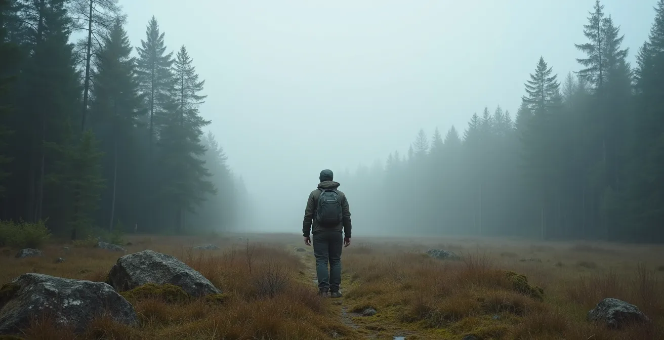
The scenario is a recurring nightmare for any adventurer in Northern Ontario: the screen on your GPS flickers and dies. The power bank is spent, the signal is lost under a dense canopy of spruce and fir, or the cold has simply drained the last of its life. The silence that follows is profound, broken only by the whine of black flies. In this moment, the realization dawns that you are not just lost; you are stripped of the one tool you trusted above all others. Many believe the solution is as simple as carrying backups—a satellite phone, another GPS. But this thinking is flawed. It perpetuates a dangerous over-reliance on technology that is fundamentally unsuited for the harsh realities of the Canadian Shield.
The true key to survival is not having more gadgets, but cultivating a deeper understanding of the environment itself. It’s about recognizing that a compass and map are not relics, but a superior navigation system that engages your brain and connects you to the terrain. It’s about knowing why a 10°C day can be lethal, how to defeat the psychological warfare of insects without chemicals, and why sleeping directly on the beautiful, moss-covered ground is a critical mistake. This guide moves beyond the platitudes. It is built on the hard-won experience of search and rescue operations, focusing on the hidden physics and cognitive traps of the Boreal forest.
This is not a list of tips; it is a foundational shift in mindset. We will deconstruct the common failures and replace them with robust, timeless skills. The goal is to transform you from a passive technology user into an active, aware participant in the wilderness—the kind of person who doesn’t just survive, but navigates with confidence, relying on the most powerful tool available: a well-trained mind.
This article will deconstruct the most critical survival challenges you will face in Northern Ontario’s Boreal forest. Each section addresses a common, often fatal, mistake and provides a robust, field-tested system to replace it, ensuring you are prepared when—not if—your technology fails.
Summary: A Serious Guide to Wilderness Survival When Technology Fails
- Why a Compass is Essential Even If You Have a Satellite Phone?
- Why Compass Navigation is More Reliable Than GPS Under Dense Canopy?
- How to Keep Sanity During Black Fly Season Without Using DEET?
- Wet and Cold: Why Hypothermia is a Risk Even at 10°C in the Woods?
- The Shelter Mistake: Why You Shouldn’t Sleep Directly on the Ground?
- When to Turn Back: Recognizing the Signs of a Rapidly Approaching Front?
- How to Pack for the Arctic Tundra: The Gear You Cannot Rent?
- Satellite Phone or InReach: What Do You Need Above the Tree Line?
Why a Compass is Essential Even If You Have a Satellite Phone?
A satellite phone provides a false sense of security. While invaluable for a rescue call, it is a poor primary navigation tool. Its GPS function is subject to the same failures as any other electronic device: battery depletion, damage from impact or water, and signal loss under a thick forest canopy. Search and rescue data confirms this dependency is a leading cause of emergencies. According to data from U.S. national parks, becoming lost is a primary factor in a significant number of incidents, with an analysis showing it as a contributing cause in 42% of the 46,609 search and rescue cases reviewed. The issue is a fundamental misunderstanding of tool hierarchy.
A compass is not a “backup”; it is the primary system. It is a mechanical instrument impervious to battery failure, cold, or canopy cover. Its function is absolute, governed by the Earth’s magnetic field. When paired with a topographical map, it enables you to understand the terrain, not just your position as a dot on a screen. This system allows you to orient yourself to landmarks, follow a bearing, and triangulate your position with a level of reliability that no electronic device can guarantee. Having a satellite phone is crucial for the final step—calling for help—but a compass and map are what prevent you from needing to make that call in the first place.
The photo below shows the core of a reliable navigation system. It is robust, independent of power, and forces a cognitive engagement with your surroundings that a GPS discourages. This is your most trustworthy guide in the Boreal forest.

Mastering this system is non-negotiable. It requires practice, but it is the single most important skill for off-grid travel. The ability to read a map and trust a compass bearing instills a confidence and situational awareness that technology can never replicate. It is the difference between being a visitor at the mercy of your gear and a competent navigator in control of your journey.
Your Action Plan: The Essential Navigation Trinity for Ontario’s North
- Always carry a quality baseplate compass (Suunto or Silva) as your primary navigation tool – it requires no batteries and works in all temperatures.
- Use topographical maps from Ontario’s LIO Topo dataset or Backroad Mapbooks to identify terrain features.
- Keep your satellite phone for emergency GPS coordinates, but understand these are useless without a map and compass to orient them.
- Practice triangulation techniques using visible landmarks before entering dense canopy areas.
- Learn to recognize glacial eskers and water flow patterns as natural navigation aids when technology fails.
Why Compass Navigation is More Reliable Than GPS Under Dense Canopy?
The dense canopy of Northern Ontario’s Boreal forest creates a significant challenge for GPS technology. The thick layers of spruce, fir, and pine can block or scatter satellite signals, leading to inaccurate readings or a complete loss of connection. This is a systemic vulnerability. In contrast, a magnetic compass operates independently of overhead conditions. Its reliability is not contingent on a clear view of the sky, making it the superior tool for navigating through thick bush. But the advantage goes far beyond simple signal reliability; it is cognitive.
Using a GPS fosters a passive, disengaged mindset. You become focused on following a digital icon, effectively outsourcing your situational awareness to a machine. This “follow the dot” mentality prevents you from building a mental map of your surroundings. You may know where you are on the screen, but you don’t understand your position relative to the landscape—the ridgelines, valleys, and water systems that define the terrain. When the screen goes dark, you are not just without a map; you are mentally lost.
Compass-and-map navigation forces a fundamentally different and more robust level of thinking. As survival instructor Andrew Herrington notes, this traditional method requires active participation:
GPS encourages a ‘follow the dot’ mentality, while compass-and-map navigation forces a deeper cognitive engagement with the terrain—recognizing ridgelines, wetlands, and creek systems
– Andrew Herrington, Survival instructor and wildlife ranger
This cognitive engagement is a survival skill in itself. It forces you to constantly observe, orient, and decide. You learn to read the contour lines on your map and see them reflected in the landscape ahead. You identify a distant peak or the direction of a creek’s flow and use it to confirm your travel. This process builds a resilient, internal sense of direction that persists even if you lose your equipment. It is the skill of true navigation, not mere positioning.
How to Keep Sanity During Black Fly Season Without Using DEET?
In Northern Ontario, from mid-May to July, black flies and mosquitoes are not just an annoyance; they are a significant psychological stressor. The constant swarming, biting, and relentless noise can erode morale, impair judgment, and lead to poor decision-making. Relying solely on chemical repellents like DEET is often insufficient and unsustainable on extended trips. A more holistic and effective strategy involves physical barriers, traditional knowledge, and mental discipline. The goal is not just to prevent bites, but to maintain your sanity and operational focus.
The most effective physical defense is a purpose-built bug jacket. The Original Bug Shirt, an Ontario-based company, has engineered a design with tightly sealed cuffs, a specialized hood with fine mesh, and a specific weave that is highly effective against the particularly aggressive black flies of the region. This is not a fashion choice; it is critical personal protective equipment. It creates a personal sanctuary, allowing you to function without the constant distraction of being swarmed.
Beyond physical barriers, traditional Indigenous knowledge offers powerful, non-chemical solutions. The Anishinaabe and Cree peoples have used ‘smudges’ for generations. As demonstrated by Caleb Musgrave, an Anishinaabe bushcraft instructor, this involves creating a protective smoke from specific plants.
Case Study: Traditional Anishinaabe and Cree Insect Deterrent Methods
Caleb Musgrave, an Anishinaabe outdoorsman from Hiawatha, Ontario, teaches the use of traditional smudges for insect control. This involves burning materials found in the Boreal forest, such as chaga mushroom or dried sage, to create a consistent smoke barrier. When stationary in camp, this low-impact, culturally significant method provides an effective, non-chemical zone of protection, a technique honed over centuries of living in this exact environment.
This approach, combined with cognitive techniques to manage the psychological pressure, forms a complete system. You must treat the insect season as a test of mental endurance, not just a physical discomfort. Establishing a bug-free zone for eating and sleeping is crucial for morale.
Your Action Plan: Mental and Physical Strategies for Black Fly Season
- Invest in the Original Bug Shirt (Ontario-based company) – its specific design with sealed cuffs and integrated hood is superior for Northern Ontario’s intense black flies.
- Create traditional ‘bush smudges’ using dried sage or chaga mushroom found locally – maintain a small smoke source when stationary.
- Practice cognitive distraction techniques: count your steps, recite memorized passages, or focus on bird calls to manage the psychological stress of constant swarming.
- Establish ‘bug-free zones’ using tarps and mosquito netting for meal times to maintain morale.
- Time activities for windier periods when insect activity naturally decreases.
Wet and Cold: Why Hypothermia is a Risk Even at 10°C in the Woods?
One of the most insidious dangers in the Boreal forest is misunderstanding hypothermia. Many adventurers associate it with freezing, sub-zero conditions. This is a fatal mistake. Your body can enter a state of hypothermia in cool, damp weather, even at temperatures well above freezing. The combination of moisture and wind is the critical factor. Water conducts heat away from the body 25 times faster than air. When your clothes are wet from rain, sweat, or a slip in a creek, and a cool 10°C wind picks up, your body’s core temperature can plummet dangerously fast. Wilderness survival experts warn that hypothermia can occur at 65°F (18°C), and the risk increases significantly as temperatures drop and moisture is introduced.
The choice of clothing is therefore not about comfort, but about thermal regulation and survival. Cotton is exceptionally dangerous; it absorbs moisture, loses all insulating properties, and actively cools you. Modern synthetics and, notably, traditional wool are far superior. Stanfield’s wool, a Canadian heritage brand, is legendary among serious outdoorspeople for its ability to insulate even when wet. It is heavy and slow-drying, but its reliability in cold, damp conditions is unmatched.
The following table provides a clear comparison of the materials best suited for Northern Ontario’s unpredictable conditions. As this paddling skills guide for the region highlights, understanding these properties is fundamental to building a safe layering system.
| Feature | Stanfield’s Wool | Modern Synthetics |
|---|---|---|
| Warmth When Wet | Retains 80% insulation | Retains 40-60% insulation |
| Drying Time | Slow (8-12 hours) | Fast (2-4 hours) |
| Odor Resistance | Naturally antimicrobial | Requires treatment |
| Durability | Excellent (decades) | Good (5-10 years) |
| Weight | Heavy when wet | Lightweight even wet |
| Cost | Higher initial investment | More affordable |
Staying dry is the primary goal. This means using waterproof outer layers and managing your exertion to minimize sweating. But when you do get wet, having a base and mid-layer of high-quality wool or a modern synthetic equivalent is what will keep your core temperature stable. This isn’t just a gear choice; it’s a life-saving system.
The Shelter Mistake: Why You Shouldn’t Sleep Directly on the Ground?
After a long day of travel, the soft, moss-covered floor of the Boreal forest can look deceptively inviting. Lying down directly on the ground, even in a high-quality sleeping bag, is a critical and potentially fatal shelter mistake. The ground acts as a massive heat sink. Through a process called thermal conduction, it will relentlessly draw warmth from your body all night long. The Canadian Shield’s granite bedrock and water-logged sphagnum moss are particularly efficient at this, meaning you will lose precious body heat far faster than you can generate it, leading to a miserable night, exhaustion, and an increased risk of hypothermia.
The solution is insulation—creating a barrier between you and the ground. Nature itself provides the perfect model and materials. Observing wildlife is not just an idle pastime; it’s a lesson in survival. This principle of biomimicry is key to effective wilderness living.
The hands in the image below are not just making a bed; they are building a survival system. They are creating a thick, insulating mattress from the materials the forest provides, breaking contact with the cold, wet earth.
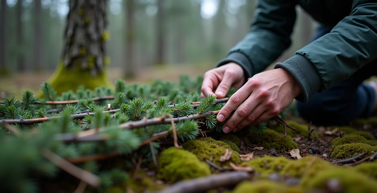
This technique, learned from the very animals that thrive in this environment, is a fundamental skill. It is more important than the R-value of your sleeping pad or the temperature rating of your bag, because without it, both are compromised.
Case Study: The Snowshoe Hare Bed Technique
Wildlife observation in Northern Ontario reveals how snowshoe hares survive. They create insulated nests called ‘forms’ by layering forest debris. By mimicking this technique, you can construct a raised, dry bed using spruce and balsam fir boughs. The key is to arrange them in overlapping layers 8-12 inches thick. This biomimicry approach provides superior insulation from the cold, wet granite and sphagnum moss characteristic of the Canadian Shield, creating crucial air pockets that trap warmth.
Your Action Plan: Boreal Forest Floor Insulation Guide
- Identify spruce and balsam fir trees – their boughs provide superior insulation compared to other conifers.
- Harvest boughs sustainably by taking only lower dead branches or thinning from multiple trees.
- Create a foundation layer perpendicular to your body, minimum 6 inches thick.
- Add a second layer parallel to your body, creating air pockets for insulation.
- Top with softer materials like dry moss or grass for comfort, avoiding direct contact with wet sphagnum.
- Ensure the bed extends beyond your body dimensions to prevent rolling onto cold ground.
When to Turn Back: Recognizing the Signs of a Rapidly Approaching Front?
In the vast, open landscapes of Northern Ontario, weather can change with frightening speed. A calm, sunny day can deteriorate into a violent storm with high winds and driving rain in a matter of hours. The decision to push on or turn back and seek shelter is one of the most critical judgments you will make. Waiting for the first drops of rain is waiting too long. The wilderness, however, provides ample warning to the observant. You must learn to read the two primary forecast systems: the sky above you and the wildlife around you.
Large bodies of water like Lake Nipigon or the exposed shores of Pukaskwa National Park act as natural observatories for atmospheric changes. Specific cloud formations are reliable harbingers of approaching weather systems. Ignoring them is a grave error.
Case Study: Reading Weather Patterns Over Lake Nipigon
Environment Canada data from the region shows that specific cloud types are highly predictive. Wispy, high-altitude cirrus clouds that look like ‘mares’ tails’ or a dappled ‘mackerel sky’ (altocumulus) are classic signs of an approaching low-pressure front. These formations typically precede a storm by 12-24 hours, giving an experienced traveller a crucial window to alter plans, find a secure campsite, or turn back entirely before conditions become hazardous.
Even more immediate are the behavioural cues from local wildlife. Animals are exquisitely sensitive to changes in barometric pressure and are often the most accurate short-term weather indicators. Their collective behaviour acts like a “barometric knee,” signaling imminent changes long before you might feel them.
Your Action Plan: The Barometric Knee – Animal Behavior Weather Indicators
- Watch for squirrels frantically gathering food – indicates a pressure drop within 2-4 hours.
- Listen for loons flying low over water instead of their normal altitude – a storm is approaching within 6 hours.
- Note the sudden silence of songbirds – an immediate weather change is imminent.
- Observe insects flying closer to ground level – rain is likely within 1-2 hours.
- Monitor deer and moose moving to dense cover – severe weather is expected within 12 hours.
Trust these signs. An ecosystem-wide shift in behaviour is a far more reliable indicator than a weather app that has no signal. Learning to see and hear these warnings is a fundamental part of safe travel.
How to Pack for the Arctic Tundra: The Gear You Cannot Rent?
As you venture north of the Boreal forest into the Hudson Bay Lowlands, the environment becomes even less forgiving. Here, on the edge of the Arctic, the concept of “renting gear” becomes a liability. Outfitters can provide basic equipment, but the most critical components of your survival system are intensely personal and cannot be outsourced. Your life will depend on gear that is personally selected, broken-in, and customized for your body and needs. Relying on generic rental items in this landscape is inviting failure.
The primary example is footwear. The terrain is a challenging mix of wet muskeg, sharp rocks, and pockets of permafrost. Rental boots, which are never perfectly fitted, will almost certainly cause debilitating blisters and hot spots within the first day. A personally owned and thoroughly broken-in two-part footwear system—a waterproof outer boot with a custom-fitted, removable insulated liner—is non-negotiable. As the wilderness outfitters at the Ontario Sea Kayak Centre emphasize, this specialized system is essential for the unique challenges of the tundra.
This principle of “un-rentable” gear extends to your entire core survival system. A sleeping bag’s temperature rating is only reliable if you know its history; a rental bag’s insulation is often compressed and degraded, offering a fraction of its stated warmth. Your sleeping pad must have a high R-value (a measure of insulation) to protect you from the frozen ground. Your first-aid kit must be customized with high-quality blister treatment like moleskin and any personal prescriptions. These are not areas for compromise.
Your Action Plan: Essential Personal Gear for the Hudson Bay Lowlands
- Invest in personally broken-in waterproof outer boots with removable insulated liners – rental boots guarantee blisters on muskeg terrain.
- Pack your own high R-value sleeping pad (R-value 5+) – rental pads often have compressed insulation.
- Bring a conservatively rated sleeping bag (comfort rating 10°C below expected temps) – never trust rental bag ratings.
- Customize your first-aid kit with quality moleskin, personal prescriptions, and bear banger pens not included in rentals.
- Purchase merino wool base layers that fit your body perfectly – rental clothing rarely provides proper layering fit.
In the far north, your personal gear is your lifeline. It represents an investment in your own safety that cannot be delegated or rented. Every item must be known, tested, and trusted.
Key Takeaways
- Your primary navigation system must be a map and compass; electronic devices are secondary tools prone to failure.
- Survival is about mastering environmental physics: understand heat loss through conduction (shelter) and convection (wet clothing) to prevent hypothermia.
- The wilderness communicates its state through animal behaviour and cloud formations; learning to read these signs is more reliable than a weather app with no signal.
Satellite Phone or InReach: What Do You Need Above the Tree Line?
Once you have mastered the fundamental skills of navigation, shelter, and environmental awareness, the final piece of your safety system is the ability to call for help in a true emergency. Above the tree line, in the vast and isolated Hudson Bay Lowlands, this is the one area where technology is not a backup, but a primary tool. However, not all satellite communication devices are created equal. The choice between a satellite phone and a two-way messenger like a Garmin InReach depends on a clear understanding of their strengths and weaknesses in this specific environment.
A satellite phone’s primary function is voice communication. While seemingly ideal, it has significant drawbacks in the far north. Voice calls require a strong, stable connection, which can be difficult to maintain. They are also extremely power-intensive, drastically shortening battery life. An InReach device, which operates on the highly reliable Iridium satellite network, uses brief bursts of data for two-way text messaging. This requires far less power and a less perfect connection, making it more dependable in remote tundra conditions. It also allows for non-urgent communication, like receiving critical weather updates from a designated contact, which is a major advantage in the rapidly changing arctic climate.
This decision requires a careful cost-benefit analysis based on the realities of the far north. Official sources like the Canadian Coast Guard, who regularly conduct search and rescue operations in these areas, base their own communications on reliability and functionality. The following comparison, based on real-world use in Northern Ontario, clarifies the choice for the serious adventurer. As this official guidance for recreational boaters suggests, choosing the right communication tool is a critical safety decision.
| Feature | InReach Device | Satellite Phone |
|---|---|---|
| Communication Type | Two-way text messaging | Voice calls |
| Reliability in Tundra | High (low bandwidth needs) | Variable (connection drops) |
| Weather Updates | Yes (via contacts) | Limited |
| Battery Life | 100+ hours | 5-30 hours talk time |
| Monthly Cost (Ontario) | $15-65 CAD | $50-150 CAD |
| Coverage Quality | Iridium network – excellent | Varies by provider |
For most situations in the Hudson Bay Lowlands, the InReach device offers a more robust, versatile, and reliable emergency communication system than a traditional satellite phone. Its long battery life, reliable messaging, and ability to receive crucial updates make it the superior choice for safety above the tree line.
The ultimate goal is to never need to press the SOS button. True safety is not found in a gadget, but in the knowledge this guide provides. It is in the mastery of the compass, the respect for the cold, and the ability to read the language of the forest. The next step is not buying more gear; it is committing to practicing these fundamental skills in a controlled environment until they become second nature. Your life may depend on it.
Frequently Asked Questions on Northern Ontario Survival Tech
Can I rent a satellite communication device in Northern Ontario?
Yes, outfitters in towns like Cochrane and Moosonee offer satellite phone rentals, though InReach devices may have limited availability. Expect to pay $50-75 per week for basic units.
Which satellite network works best in the far north of Ontario?
The Iridium network provides the most consistent coverage in Northern Ontario’s remote areas, particularly above the tree line near Polar Bear Provincial Park.
How do weather updates via InReach work?
You can designate a contact to send you weather forecasts via text message. This person checks weather services and sends you condensed updates, crucial for the rapidly changing tundra conditions.