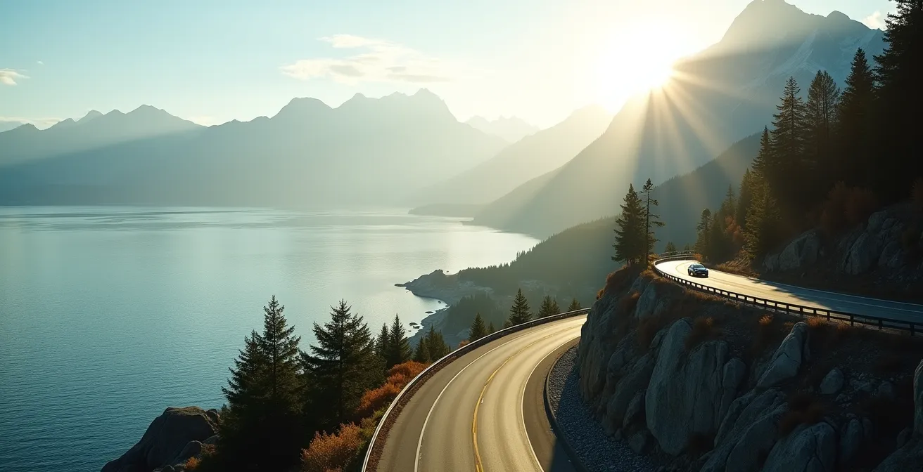
Driving the Sea-to-Sky on a Friday isn’t about leaving at 5 AM; it’s about understanding and exploiting the corridor’s predictable traffic “pulse”.
- Minor stops like Shannon Falls and the Sea-to-Sky Gondola create traffic waves that you can time and strategically avoid.
- Maximizing your trip involves using underrated pull-offs as tactical pauses and leveraging counter-flow mountain movement at Whistler.
Recommendation: Stop thinking about *when* you leave Vancouver and start thinking about *how* you navigate the micro-flows along the entire route to Whistler.
For any Vancouverite or tourist, the Friday morning exodus to Whistler feels like a rite of passage, often marked by brake lights and frustration. The common advice is always the same: leave at dawn or risk spending hours in gridlock. While well-intentioned, this advice misses the fundamental nature of the Sea-to-Sky Highway. This isn’t just a simple A-to-B route; it’s a dynamic corridor with its own rhythm, a predictable pulse of traffic shaped by key attractions and driver behaviour.
The standard approach focuses only on the start time, ignoring the journey itself. But what if the secret wasn’t just about avoiding traffic, but outsmarting it? The key to a smooth drive lies in understanding the corridor’s ‘micro-flows’—the small, predictable patterns of movement caused by popular stops. It’s about knowing where the choke points will form an hour after you’ve left the city and positioning yourself to bypass them.
This guide moves beyond the generic “leave early” mantra. We will deconstruct the highway’s traffic patterns, treating the journey not as a race against the clock, but as a strategic navigation exercise. By learning to read the corridor’s pulse, you can use strategic pauses, anticipate bottlenecks, and transform a stressful commute into the scenic, breathtaking drive it was meant to be. This is about mastering the flow, not just being swept away by it.
This article breaks down the expert strategies you need to master the drive. We’ll cover everything from parking logistics at key waterfalls and winter road checks to finding hidden photo spots and maximizing your ski pass, giving you a complete toolkit for your next trip north.
Summary: Outsmarting the Sea-to-Sky Highway Drive to Whistler
- Why Parking at Shannon Falls is Easier on a Tuesday Than a Saturday?
- How to Verify Road Status to Alice Lake Before Driving North in Winter?
- The Best Underrated Pull-Off Between Horseshoe Bay and Squamish for Photos?
- Where Are the Dead Zones on the Sea-to-Sky Corridor?
- How Much Rain is Needed to Make the Waterfalls on the Highway “Thundering”?
- The Booking Deadline Mistake That Blocks Access to Whistler on Christmas Week
- Why Sunset Photos of the North Shore Mountains are Better from Jericho Beach than English Bay?
- How to Maximise Days at Whistler Using the Ikon Pass Without Blackout Dates?
Why Parking at Shannon Falls is Easier on a Tuesday Than a Saturday?
Understanding the parking situation at Shannon Falls is the first step to mastering the Sea-to-Sky’s traffic pulse. The issue isn’t just volume; it’s the micro-flow of traffic it creates. On a Saturday, the lot is notoriously challenging, and according to local hiking guides, it’s “ALWAYS full” after mid-morning. This creates a significant bottleneck as hopeful visitors slow down, circle the lot, or dangerously wait on the highway shoulder, causing a ripple effect of congestion that can back up for kilometres.
A Tuesday, by contrast, offers a completely different experience. With fewer tourists and locals on the road, parking is generally available throughout the day. This isn’t just about convenience; it’s a strategic advantage. A midweek visit allows you to treat Shannon Falls as a quick, stress-free stop rather than a major logistical hurdle that dictates your entire schedule. The predictable weekend chaos versus the weekday calm is a perfect example of the corridor’s pulse.
For those committed to a weekend trip, timing is everything. Arriving before 9 AM is critical to secure a spot in the official lot. If you arrive during the peak 10 AM to 2 PM window and find it full, don’t contribute to the jam. Your best strategic moves are to either proceed five minutes south to the less-crowded Murrin Provincial Park and wait out the surge, or continue north to the Sea-to-Sky Gondola’s overflow lot and plan to visit the falls on your return journey. This proactive approach prevents you from becoming part of the problem.
How to Verify Road Status to Alice Lake Before Driving North in Winter?
Driving the Sea-to-Sky corridor in winter introduces variables far more critical than traffic: weather and road conditions. Heading to a destination like Alice Lake Provincial Park requires more than just a set of winter tires; it demands a pre-drive intelligence check. Snowfall at higher elevations, black ice in shaded canyons, and sudden closures can turn a scenic drive into a hazardous situation. The key is to shift from a passive driver to a proactive planner by using a digital toolkit to get a real-time picture of the entire route.
Your vehicle must be compliant with provincial law, which mandates winter tires from October 1 to March 31. However, compliance is just the starting point. True preparedness means knowing the specific conditions you’ll face. Is the snow level dropping? Is rain at sea level turning to ice near Squamish? Answering these questions before you leave Horseshoe Bay is crucial for safety and for avoiding hours-long delays due to accidents or closures. This proactive verification is a non-negotiable part of any winter trip north.
This paragraph introduces the complex variables of winter driving. Visualizing the conditions you might face is a key part of preparation. The illustration below captures the reality of the highway under a blanket of fresh snow.
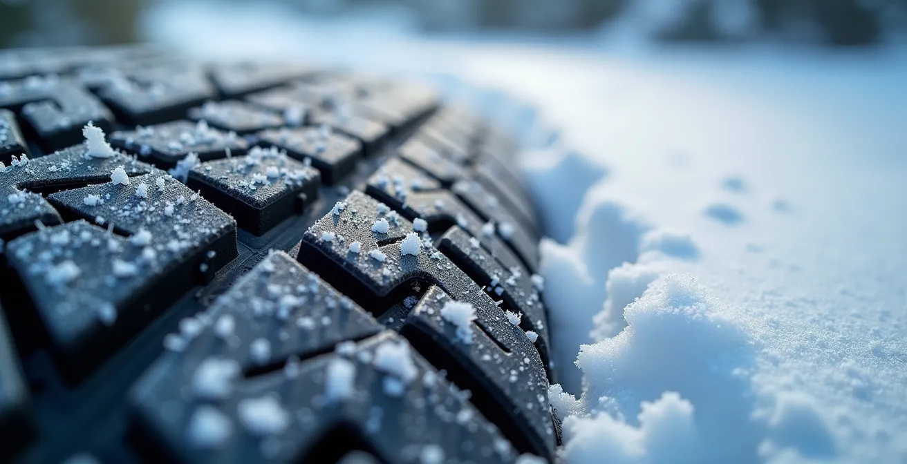
As this image demonstrates, a beautiful winter scene can conceal challenging driving conditions. Relying on a single source of information is a common mistake. A comprehensive check involves consulting multiple platforms to build a complete operational picture of the corridor.
Your Essential Sea-to-Sky Winter Driver’s Digital Toolkit
- Check DriveBC: Use the official government website for real-time road conditions, incident reports, and webcam views along Highway 99.
- Monitor Local Radio: Tune into Mountain FM (107.1 in Squamish, 102.1 in Whistler) for live traffic and weather updates from a local perspective.
- Review Freezing Levels: Consult Environment Canada’s forecast to understand the elevation at which rain will turn to snow or create black ice.
- Assess Overnight Conditions: Check the 10 PM to 6 AM forecast for Squamish to gauge the risk of black ice forming in the early morning.
- Confirm Tire Compliance: Double-check that your M+S or mountain/snowflake tires are in good condition and meet the requirements for the October 1 to March 31 period.
The Best Underrated Pull-Off Between Horseshoe Bay and Squamish for Photos?
While many drivers fixate on reaching Squamish or Whistler, some of the most spectacular views along the Sea-to-Sky Highway are found at its simple, often overlooked pull-offs. These spots are more than just a place to stretch your legs; they are strategic pauses that allow you to let traffic waves pass while capturing incredible photos. The key is to skip the crowded, well-marked viewpoints and seek out the underrated gems. Between Horseshoe Bay and Squamish, the single best option for this is the Tantalus Lookout.
Unlike larger stops that have their own micro-traffic jams, the Tantalus Lookout is a simple pullout that offers a world-class view with minimal fuss. It provides the first clear, sweeping vista of the glaciated peaks of the Tantalus Range. These “jagged, glaciated peaks” create a stunning contrast with the forested cliffs below. On clear days, the distant icefields catch the sun, creating a sparkling effect that is difficult to capture from a moving vehicle. It’s the perfect spot to appreciate the sheer scale of the landscape without committing to a long hike.
Using these pull-offs is also a matter of safety. The highway’s winding nature and changing conditions historically led to a high number of incidents, highlighting the importance of safe pull-offs according to historical data, which recorded an average of 574 accidents per year between 1998 and 2004 before major upgrades. Stopping at a designated, well-sighted lookout like Tantalus is infinitely safer than pulling over on a narrow shoulder. It transforms a risky impulse photo into a planned, safe, and rewarding experience, allowing the main flow of traffic to continue unimpeded.
Where Are the Dead Zones on the Sea-to-Sky Corridor?
In an age of constant connectivity, the Sea-to-Sky Highway serves as a stark reminder that digital access is not guaranteed. The corridor is notorious for cellular “dead zones,” particularly in the steep, canyon-like sections between Squamish and Whistler. Losing signal is not just an inconvenience; it’s a safety issue that can disrupt navigation, prevent communication, and complicate emergencies. Knowing where these dead zones are and preparing for them is a core component of an expert’s travel plan.
The most significant dead zones typically begin north of Squamish and persist through areas like Cheakamus Canyon and around Brandywine Falls. In these sections, the granite cliffs and winding topography effectively block cell signals for all major Canadian carriers. This means your streaming music will stop, your live map updates will cease, and you won’t be able to make a call or send a text. For anyone relying on a phone for navigation or coordinating with others, this can quickly lead to confusion and missed connections.
This paragraph discusses the reality of losing digital connection in a remote area. The illustration below symbolically represents the shift from digital reliance to analog preparedness that is required when entering a signal dead zone.
As the image suggests, navigating without a signal requires a return to fundamentals. The solution is to prepare for disconnection before you enter these zones. This means transitioning your digital tools to offline mode and establishing a clear communication plan. Before losing your signal, pre-load your playlists and download the entire map route for offline use in Google Maps or your preferred app. Send an “entering dead zone” ETA text to your destination contact. If traveling in a convoy, agree on a designated meeting point, such as the Brandywine Falls parking lot, in case you get separated.
How Much Rain is Needed to Make the Waterfalls on the Highway “Thundering”?
The waterfalls along the Sea-to-Sky are a major draw, but their visual impact varies dramatically with recent weather. A common question from visitors is how much rain it takes to transform them from a gentle trickle into a “thundering” cascade. The answer lies in understanding the correlation between rainfall measurements and water flow, allowing you to time your visit for maximum spectacle. This is especially true for Shannon Falls, which, according to BC Parks official data, is the third highest falls in British Columbia, rising an impressive 335 metres.
The power of the waterfalls is directly tied to the amount of precipitation in the preceding 24-48 hours. A light shower won’t suffice; a significant, sustained rainfall is required to saturate the ground and feed the creeks that supply the falls. As a general rule, a “good” waterfall day follows at least 25 mm of rain. This amount is enough to make Shannon Falls noticeably more powerful and impressive. For a truly “roaring” experience at a spot like Brandywine Falls, you’ll want to see rainfall closer to 50 mm.
The most dramatic displays occur after major weather events, often referred to as “atmospheric rivers.” When rainfall totals exceed 75 mm, the entire corridor comes alive. Not only are the main attractions at peak flow, but dozens of unnamed, ephemeral waterfalls appear, cascading down the cliffs of Cheakamus Canyon. To plan your trip for this experience, use a weather tool like Windy.com to check the “Accumulated Precipitation” map for the Squamish area. The best viewing seasons are typically the spring melt (March-May) and the fall rainy season (October-November), when these powerful weather systems are most common.
The Booking Deadline Mistake That Blocks Access to Whistler on Christmas Week
For many, a Whistler ski trip during Christmas week is the ultimate holiday dream. However, this dream can quickly turn into a logistical nightmare if you’re an Ikon Pass holder who overlooks one critical detail: blackout dates. The most common and costly mistake is assuming your pass provides unrestricted access during the busiest time of the year. Failing to check the fine print can leave you at the base of the mountain with an invalid pass and no way to ski.
Specifically for the Ikon Pass, the period around Christmas and New Year’s is a designated blackout period for many pass types. For the upcoming season, this is confirmed by the official Ikon Pass blackout schedule, which lists December 26, 2024, to January 1, 2025, as restricted dates for the Ikon Base Pass at Whistler Blackcomb. Travellers who book flights and non-refundable accommodation without verifying this detail are often faced with the expensive reality of having to buy full-price lift tickets, if any are even available.
Beyond lift access, planning a Christmas week trip requires a military-style approach to booking. Competition for every service is fierce. Accommodations should be booked by October at the latest to avoid astronomical pricing. Ski lessons and equipment rentals fill up fast and should be secured in early November. Even dinner reservations for Christmas Eve and New Year’s Eve need to be made by early December. For those staying off-mountain, parking reservations are another crucial step, with deadlines often around November 1st. Missing these deadlines doesn’t just mean inconvenience; it can genuinely block your access to the full Whistler experience.
Why Sunset Photos of the North Shore Mountains are Better from Jericho Beach than English Bay?
Capturing the perfect sunset photo of Vancouver’s skyline against the North Shore Mountains is a quintessential local experience. Many tourists and new residents naturally gravitate to English Bay or Kitsilano Beach, drawn by their central location and lively atmosphere. While these are fantastic spots to watch the sun go down, for serious photography, Jericho Beach offers a distinct and superior advantage based on pure compositional geometry.
The primary reason comes down to the angle and layering. From English Bay, the view is more direct; the downtown skyline and the mountains can appear compressed together. From Jericho Beach, located further west, your line of sight angles eastward. This creates a beautiful visual separation and layering effect: the foreground of the beach, the middle ground of the downtown skyline, and the background of the North Shore Mountains. At sunset, this angle allows the golden hour light (the alpenglow) to rake across the mountain faces, making them glow, while the city skyline falls into a dramatic silhouette. This creates depth and contrast that is much harder to achieve from a more frontal viewpoint.
This paragraph explains the technical and artistic reasons for choosing a specific location. The illustration below perfectly captures the resulting composition from Jericho Beach, with the photographer embodying the scene’s potential.
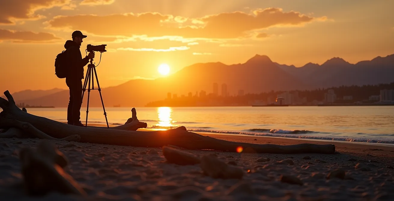
As depicted, the composition from Jericho allows for more creative framing. The abundance of driftwood logs provides strong leading lines to draw the viewer’s eye towards the city and mountains. Furthermore, Jericho is generally quieter and less crowded than Kitsilano or English Bay, offering a more peaceful environment to set up a tripod and wait for the perfect light without constant interruptions. It provides the space and the superior angle needed to transform a simple sunset snapshot into a stunning landscape photograph.
Key Takeaways
- Master the “Corridor Pulse”: Avoid traffic by understanding the micro-flows created by major stops like Shannon Falls and the Sea-to-Sky Gondola.
- Use Strategic Pauses: Utilize underrated pull-offs like the Tantalus Lookout not just for photos, but as tactical waiting areas to let traffic waves pass.
- Prepare for Disconnection: Pre-load maps and communicate ETAs before entering the known cellular dead zones between Squamish and Whistler.
How to Maximise Days at Whistler Using the Ikon Pass Without Blackout Dates?
Simply having an Ikon Pass without blackout dates is only the first step to maximizing your time at Whistler. The next level of strategy involves understanding how to navigate the mountain itself to avoid crowds and ski more vertical. The key is to employ a “counter-flow” mindset, moving against the predictable tide of skiers and snowboarders who follow the same patterns day after day. This allows you to spend more time on the slopes and less time in lift lines, even on busy days.
The difference between pass types is a crucial starting point. For instance, an Ikon Base Pass has blackout dates on “Dec. 26 – 31, 2024” and other holiday weekends, while the full Ikon Pass offers unrestricted access. For those with the full pass, the quietest days on the mountain are invariably Tuesday and Wednesday. If you must ski on a weekend, your strategy should be to start your morning on Whistler Mountain, as the Blackcomb base (and the new Fitzsimmons Express) tends to be the busiest access point early in the day. Use the Peak 2 Peak Gondola mid-day, when most people are taking a lunch break, to move between mountains with minimal wait times.
For the ultimate advantage, book First Tracks access. This gets you on the mountain two hours before it opens to the general public, guaranteeing pristine groomers and no lines. Finally, leverage the perks of your pass. If you have friends joining who need day tickets, use your Friends & Family 25% discount on off-peak days to save them money and encourage them to ski with you when the mountain is less crowded. By combining pass knowledge with an on-mountain counter-flow strategy, you can extract maximum value from every day of your trip.
By adopting this expert mindset—treating the journey and the destination as a series of strategic choices rather than a simple trip—you fundamentally change your relationship with the Sea-to-Sky corridor. Start applying these principles on your next drive north to transform a potentially stressful commute into a seamless and enjoyable part of your Whistler adventure.