Driving the Icefields Parkway late isn’t about seeing everything; it’s about seeing the right things before sunset.
- Prioritize three high-impact stops: Sunwapta Falls, Athabasca Falls, and the Goats and Glaciers Viewpoint.
- Acknowledge the 103 km fuel desert after the Icefield Centre and the 30% drop in gas mileage due to elevation.
Recommendation: Fill your tank completely in Lake Louise and treat your remaining daylight as a non-renewable budget.
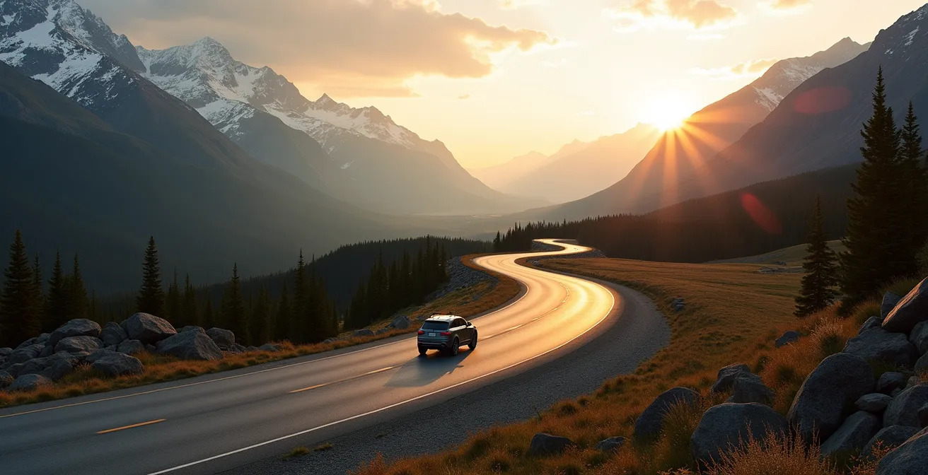
The sinking sun casts long shadows across the mountains. You’ve just left Lake Louise, and a glance at the clock confirms your fear: you have, at most, four hours of usable daylight to conquer the legendary Icefields Parkway. Panic sets in. Every blog and travel guide screams “take your time,” “start early,” and offers an endless list of over a dozen “must-see” stops. This advice is now useless to you. It’s a fantasy for a trip you didn’t take.
Your situation is different. This isn’t a leisurely tour; it’s a logistical mission against a hard deadline. Success isn’t measured by how many photos you take, but by reaching Jasper safely without missing the truly non-negotiable sights and without running out of gas in a cellular dead zone. Forget the comprehensive lists. You need a tactical plan based on ruthless prioritization and risk mitigation.
This guide is your mission briefing. We will discard the nice-to-haves and focus exclusively on the mission-critical. We’ll analyze stops based on their “time-to-value” ratio, address the real risks of a late start like fuel consumption and wildlife encounters, and even reveal an opportunity that only presents itself after the sun has set. Your objective is simple: extract the maximum value from every remaining minute of daylight.
To help you navigate this high-stakes drive, this article breaks down the essential decisions you need to make. We’ll cover the absolute priority viewpoints, critical safety procedures for wildlife and night driving, and the all-important fuel logistics that can make or break your journey.
Summary: A Mission-Critical Guide to the Icefields Parkway
- The Top 3 Viewpoints You Must See Between Saskatchewan River Crossing and Jasper?
- How to Safely Navigate a Wildlife Jam Without Disturbing the Animals?
- When is the Next Gas Station After the Columbia Icefield Centre?
- The Best Time to Photograph the Athabasca Glacier Ice Colour?
- What Date Does the Icefields Parkway Usually Require Winter Tires?
- Why Your Gas Mileage Drops by 30% When Driving the Icefields Parkway?
- How Long Does it Take to Drive the Parkway After Sunset in August?
- How to Visit Moraine Lake, Lake Louise, and the Icefields Parkway in a Single 14-Hour Day?
The Top 3 Viewpoints You Must See Between Saskatchewan River Crossing and Jasper?
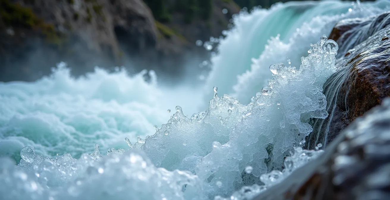
With a dwindling daylight budget, every stop is a calculated expense. Your goal is the highest possible “time-to-value” ratio. Forget the minor pull-offs; focus on these three mission-critical stops north of the Crossing. They offer maximum geological drama for a minimal time investment. First is Sunwapta Falls. Budget 30 minutes. The 1km trail to the upper and lower viewpoints is essential, as the deep canyon walls catch spectacular, dramatic side-lighting in the late afternoon. This isn’t just a waterfall; it’s a lesson in hydro-geology, with three distinct levels carved by hanging valleys.
Next, allocate 45 minutes for Athabasca Falls. Accessed via the Highway 93A junction, its power is in its volume, not its height. The paved trail system allows for multiple angles of the 23-meter cascade. Late afternoon is ideal, as the low western sun illuminates the mist rising from the canyon, creating an ethereal glow. This stop provides the most powerful sensory experience of water shaping rock.
Your final mandatory stop is the quickest: the Goats and Glaciers Viewpoint, requiring only 15 minutes. This simple roadside pull-off near the 106 km marker offers a sweeping panorama of the Athabasca River valley. More importantly, it’s a high-probability zone for spotting mountain goats on the distant cliff faces. This stop delivers the iconic “wildlife and vast landscape” shot with minimal effort. To afford these, you must ruthlessly skip Stutfield Glacier and Mount Kitchener viewpoints, which are in shadow late in the day, and Tangle Falls, which has low flow in late season.
How to Safely Navigate a Wildlife Jam Without Disturbing the Animals?
A “wildlife jam”—a line of stopped cars with tourists gawking at an animal—is almost a certainty. For you, it’s not a photo op; it’s a time-sink and a safety risk. Navigating it requires discipline, not a long lens. The absolute first rule is to respect the animal’s space. To prevent stressing wildlife and causing dangerous situations, you must adhere to Parks Canada’s mandatory wildlife viewing distances: 100 meters for bears, wolves, and cougars, and 30 meters for elk, moose, sheep, and goats. These are legal requirements, not suggestions.
If you are the first to spot a large animal, do not stop in the middle of the road. If a jam has already formed, your priority is safety and efficiency. Do not get out of your car. An elk may seem placid, but it is a powerful, wild animal. Your car is your armour. The goal is to observe safely and briefly, then move on to stay on schedule. If an animal shows any signs of stress, such as raised hackles, vocalizing, or pawing the ground, it’s a clear signal to leave the area immediately.
Action Plan: Wildlife Jam Protocol
- Approach with Caution: Reduce your speed gradually to 30 km/h when you see stopped vehicles or an animal near the road.
- Secure Your Vehicle: Pull completely off the road onto the shoulder, ensuring you are not on the soft gravel edge. Engage your parking brake and activate hazard lights.
- Minimize Disturbance: Turn off your engine to reduce noise and stress on the animal. Observe from inside your vehicle using binoculars or a telephoto lens.
- Read the Signs: If the animal appears agitated or is a bear with cubs, start your engine and leave the area immediately. Your presence is a threat.
- Report if Necessary: If you witness aggressive wildlife or people endangering animals, report it to Parks Canada Dispatch at 403-762-1470 once you have cell service.
When is the Next Gas Station After the Columbia Icefield Centre?
This is the single most critical logistical question for a late-day driver. The answer is stark: there is no gas at the Columbia Icefield Centre. After you pass the seasonal, high-priced pumps at Saskatchewan River Crossing, you are entering a fuel desert. The next reliable, year-round service station is a full 103 km away in the town of Jasper. Underestimating this distance is the most common and dangerous mistake a driver can make on the Parkway.
Your vehicle’s fuel gauge is now as important as the clock. Because of the factors discussed in a later section—elevation gain and cold air—your fuel consumption will be significantly higher than on a flat highway. Do not trust your car’s standard “distance to empty” reading. Assuming you can make it is a gamble you cannot afford to lose, as there is absolutely no cell service on the majority of the Parkway to call for help. Running out of fuel here, especially as dusk falls, turns a scenic drive into a genuine survival situation.
The table below clearly illustrates the scarcity of services. Before leaving Lake Louise, your tank must be completely full. This is not a suggestion; it is a prerequisite for your mission.
| Location | Distance from Lake Louise | Seasonal Availability | Services |
|---|---|---|---|
| Lake Louise | 0 km | Year-round | Full service, multiple stations |
| Saskatchewan River Crossing | 80 km | June-September only | Single pump, premium prices |
| Columbia Icefield | 127 km | No gas available | Restaurant and visitor center only |
| Jasper | 230 km | Year-round | Full service, multiple stations |
The Best Time to Photograph the Athabasca Glacier Ice Colour?
Your sunset deadline feels like a point of failure, but for one specific objective, it’s actually an advantage. While most tourists see the Athabasca Glacier under the harsh glare of midday sun, you have the opportunity to witness its true colour. The most intense, otherworldly blue of glacial ice is not visible in direct sunlight. It reveals itself during a specific, fleeting window: civil twilight.
Professional photographers know this secret. The magic happens approximately 20-30 minutes *after* the sun has dipped below the horizon. During this period, the sky is still bright, but the light is indirect. This soft, cool light penetrates the dense, ancient ice and refracts, causing the ice to glow from within with a deep, sapphire blue hue. Direct sunlight creates surface glare and washes out this spectacular effect. So, while other tourists are heading for dinner, you can be positioned at the Columbia Icefield to capture a sight they completely missed.
This turns your race against the clock on its head. Reaching the glacier just as the sun sets isn’t a failure; it’s perfect timing. You can use the last vestiges of your daylight budget for the drive, and then, as a reward, witness this post-sunset spectacle. It is a powerful reminder that on the Parkway, the best experiences often happen when you avoid the peak 1 p.m. to 3 p.m. crowds and embrace the unique conditions of the fading light.
What Date Does the Icefields Parkway Usually Require Winter Tires?
If your late-day drive is during the “shoulder seasons”—late September, October, or even early June—tire choice becomes a critical risk assessment. The weather on the Parkway is not the same as in the valleys. It can snow any month of the year at higher elevations, and a sunny afternoon in Banff can be a whiteout at Bow Summit. The date on the calendar is less important than the type of rubber on your wheels. The legal requirement for winter tires can be confusing for visitors. This is crucial because while neighbouring British Columbia has strict laws, Alberta has no legal winter tire requirement, only a strong recommendation for mountain highways.
However, Parks Canada can and will close the Parkway or require appropriate tires for passage when conditions dictate. Do not gamble. If you are travelling outside of July and August, you must have proper winter-rated tires. An “M+S” (Mud and Snow) tire is the bare minimum, but for true safety in freezing temperatures, your tires must have the Three-Peak Mountain Snowflake (3PMSF) symbol. Summer tires become hard and lose their grip below 7°C, making them incredibly dangerous on cold, wet mountain roads, even without snow.
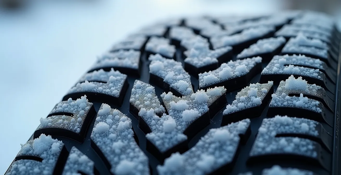
Before you even begin your drive, inspect your tires. The table below clarifies the symbols. Being stranded due to a poor tire choice is an unforced error you cannot afford, especially with nightfall approaching.
| Symbol | Name | Performance | Legal Status in Parks |
|---|---|---|---|
| M+S | Mud and Snow | Basic all-season capability | Meets minimum BC requirement |
| 3PMSF (Mountain/Snowflake) | Three-Peak Mountain Snowflake | True winter performance below -7°C | Recommended for mountain conditions |
| None | Summer tires | Poor below 7°C | Not recommended Oct-April |
Why Your Gas Mileage Drops by 30% When Driving the Icefields Parkway?
Watching your fuel gauge drop faster than expected can be terrifying in a place with no gas stations. This isn’t your imagination; a vehicle’s fuel consumption can genuinely increase by up to 30% on the Parkway compared to normal highway driving. Understanding why is key to proper planning and avoiding a catastrophic miscalculation. There are three main culprits: elevation, stopping, and air temperature.
First and foremost is elevation gain. Your engine works much harder to pull your vehicle uphill than it does on flat ground. The parkway is not a flat highway; it involves constant climbing, reaching Canada’s highest paved road point at Bow Summit, which sits at 2,088 meters, and also crossing Sunwapta Pass. Every ascent burns a significant amount of extra fuel.
Second, your driving pattern is inefficient. The frequent slowing down for viewpoints, pulling over for photos, and then accelerating back up to speed consumes far more gas than maintaining a steady highway cruise. Finally, the cold, dense mountain air affects your engine’s performance. At colder temperatures, the engine’s computer injects a richer fuel-air mixture to operate efficiently, which directly translates to higher fuel consumption. This combination of factors conspires to drain your tank at an alarming rate, which is why starting with a completely full tank from Lake Louise or Jasper is the only safe strategy.
How Long Does it Take to Drive the Parkway After Sunset in August?
Once the sun disappears behind the peaks, the character of the drive changes instantly. The majestic landscape becomes an impenetrable wall of darkness, and the road demands a new level of respect and caution. The official speed limit is 90 km/h, but driving this fast at night is reckless. Your primary mission is now hazard avoidance, specifically wildlife. The drive time will increase significantly.
As a rule, you should immediately reduce your speed to 70 km/h or less after sunset. This gives you more reaction time for the deer, elk, or even moose that frequently cross the road at dusk and during the night. You must add a minimum of 30 to 45 minutes to your remaining GPS-estimated travel time. Use your high beams constantly to scan the ditches for the tell-tale “eye-shine” of an animal, but be prepared to dim them instantly for the rare oncoming vehicle.
While summer offers extended daylight, by late in the season this dwindles significantly, with roughly 14 hours of total daylight in late August. This makes a late start particularly challenging. Be especially vigilant on the Athabasca River flats and in the final 5km stretch before the Jasper townsite, as these are notorious wildlife hotspots. Also, be aware that even in August, “summer black ice” can form in shaded valleys and near glaciers where meltwater freezes after sunset. Night driving on the Parkway is not for the faint of heart; it requires total concentration.
Key Takeaways
- Daylight is a budget: Every stop must be a calculated decision based on its time-to-value ratio.
- Fuel is non-negotiable: There is no gas at the Icefield Centre; the next station is 103 km away in Jasper, and your mileage will be 30% worse than normal.
- Safety first: The complete lack of cell service and the presence of active wildlife demand constant vigilance, especially as dusk approaches.
How to Visit Moraine Lake, Lake Louise, and the Icefields Parkway in a Single 14-Hour Day?
While your current mission is a northbound sprint against the clock, true mastery of this region involves a counter-intuitive strategy. For your next trip, when you want to see it all—Moraine Lake, Lake Louise, and the entire Parkway—without the crowds and parking chaos, do not start in Lake Louise. Instead, adopt the “Southbound Commando Strategy.” This professional guide’s approach flips the conventional itinerary on its head for a vastly superior experience.
The plan is demanding but brilliant: depart Banff or Lake Louise by 4:30 AM and drive the three hours directly to Jasper in the dark. You’ll arrive for a quick breakfast as the town wakes up. You then begin your Icefields Parkway journey southbound, travelling with the sun at your back. This timing means you hit the major northern stops like Athabasca and Sunwapta Falls in the morning light with few other visitors. You arrive at the Columbia Icefield after the early rush but before the main afternoon peak.
The real genius of this plan reveals itself at the end of the day. You reach the Peyto Lake and Bow Lake viewpoints in the mid-afternoon, and then arrive at Lake Louise and Moraine Lake in the late afternoon and early evening. By this time, the thousands of tour bus passengers have departed, parking spaces are available, and you get to experience these world-famous lakes in the glorious “golden hour” light, free from the notorious midday crowds. It’s a long day, but it transforms a stressful, crowd-filled experience into a serene and magical one.
| Time | Traditional Route | Southbound Strategy |
|---|---|---|
| 5:00 AM | Moraine Lake sunrise (crowded) | Depart Banff, drive to Jasper |
| 8:00 AM | Lake Louise (parking full) | Arrive Jasper, quick breakfast |
| 10:00 AM | Start Icefields Parkway north | Begin southbound with Athabasca Falls |
| 12:00 PM | Columbia Icefield (peak crowds) | Columbia Icefield (moderate crowds) |
| 3:00 PM | Sunwapta Falls | Peyto Lake and Bow Lake |
| 5:00 PM | Arrive Jasper (exhausted) | Lake Louise (fewer crowds) |
| 6:30 PM | Missed golden hour | Moraine Lake evening light |
Ultimately, whether you’re executing a last-minute dash or a meticulously planned southbound expedition, driving the Icefields Parkway is an exercise in preparation. Your next step is to take these tactical insights and build your own concrete, timed itinerary before you ever turn the key.