Routes & Itineraries
Planning a road trip or travel itinerary in Canada presents challenges unlike almost anywhere else in the world. The country’s sheer geographic scale—stretching 5,514 kilometres from coast to coast—combined with dramatic terrain variations, seasonal extremes, and remote sections means that effective route planning requires specific knowledge and preparation. A miscalculation in fuel range, an underestimation of driving times, or poor vehicle choice can transform an adventure into a stressful ordeal.
Whether you’re contemplating a transcontinental crossing, exploring the Maritime provinces, navigating mountain passes in the Rockies, or venturing into Newfoundland’s remote interior, understanding the fundamentals of Canadian route planning will help you travel safely, efficiently, and economically. This comprehensive resource covers everything from grasping the true scale of Canadian distances to selecting the right vehicle, navigating iconic scenic drives, and managing the practical logistics that can make or break your itinerary.
Why Canadian Route Planning Differs from Other Destinations
The single most common mistake travelers make when planning Canadian itineraries is underestimating distances. European visitors, accustomed to crossing entire countries in a few hours, often find themselves shocked when a drive from Toronto to Vancouver requires approximately 4,400 kilometres and multiple days behind the wheel. To put this in perspective, that’s roughly equivalent to driving from Lisbon, Portugal to Moscow, Russia.
This scale affects every aspect of route planning. Fuel stops can’t be treated casually—on certain routes like the Trans-Labrador Highway or sections of the Trans-Canada Highway through Northern Ontario, gas stations may be separated by 200 kilometres or more. Accommodation can’t always be booked spontaneously, particularly during peak summer months when remote communities with limited lodging fill up quickly. Cell service gaps are common outside major corridors, making real-time navigation adjustments challenging.
Canada’s terrain diversity compounds these challenges. A transcontinental route might take you from the rocky shores of Newfoundland, across the flat expanses of the Prairies, through mountain passes exceeding 1,600 metres in elevation, and down to temperate coastal rainforests—all requiring different driving techniques, vehicle preparations, and packing strategies. Understanding these fundamental differences is the cornerstone of successful Canadian route planning.
Selecting the Right Vehicle for Diverse Canadian Terrain
Vehicle choice significantly impacts both your safety and enjoyment when traveling Canada’s varied landscapes. The right selection depends on your specific route, season, and planned activities rather than a one-size-fits-all approach.
Terrain-Specific Vehicle Considerations
For mountain routes through the Rockies or coastal ranges, you’ll encounter steep grades, tight switchbacks, and potentially unpaved secondary roads leading to trailheads or viewpoints. A vehicle with adequate engine power for climbing mountain passes while maintaining safe speeds is essential. Larger RVs and motorhomes face particular challenges with parking at popular attractions like Moraine Lake or Johnston Canyon, where lot sizes are limited and larger vehicles may be restricted during peak periods.
Coastal routes like the Sea-to-Sky Highway or Cabot Trail feature winding roads with frequent stops for viewpoints and photo opportunities. Compact vehicles offer easier parking at lookouts and better fuel economy, though they provide less storage for camping gear or sports equipment. Remote routes, particularly in Newfoundland’s interior or Northern regions, may require higher clearance for gravel roads and the capacity to carry extra fuel in jerry cans when distances between services exceed your tank range.
Winter Tire Laws and Mountain Driving Requirements
British Columbia enforces mandatory winter tire requirements on mountain routes and designated highways from October through March. These aren’t recommendations—they’re legal requirements, and non-compliance can result in fines and travel delays. The tires must display the three-peaked mountain snowflake symbol, not just the M+S (mud and snow) rating, on routes like the Coquihalla Highway and mountain passes.
Even outside mandated zones, winter conditions can appear unexpectedly at higher elevations. The Icefields Parkway, which reaches elevations above 2,000 metres, has seen snowfall in every month of the year. Rental agencies in mountain communities typically equip vehicles appropriately for the season, but confirming this detail before booking prevents costly surprises or safety compromises.
Planning Routes by Region: Coast to Coast Strategies
Each Canadian region presents distinct planning considerations, from economic strategies in the Maritimes to fuel logistics in remote Newfoundland and timing considerations for Rocky Mountain routes.
Maritime Region Route Optimization
The Maritime provinces—Nova Scotia, New Brunswick, and Prince Edward Island—offer concentrated scenic value within manageable distances, but thoughtful planning still yields significant time and cost savings. The decision between ferry connections and driving around bodies of water frequently arises. For example, the ferry from Saint John, New Brunswick to Digby, Nova Scotia crosses the Bay of Fundy in roughly three hours, saving approximately 600 kilometres of driving compared to routing around through Moncton and across Nova Scotia’s interior.
Ferry costs must be weighed against fuel savings, accommodation needs, and time value. During peak summer season, ferry reservations become essential, and walk-up availability shouldn’t be assumed. Timing your itinerary to experience the Bay of Fundy at both high and low tide—a differential that can exceed 16 metres, the world’s highest tides—adds educational value without additional cost.
Rocky Mountain Corridor Routes
Routes through Banff and Jasper National Parks require different strategies than other Canadian destinations due to park-specific regulations, wildlife activity, and weather unpredictability. The Parks Canada Discovery Pass becomes cost-effective for itineraries exceeding seven days across multiple parks. Vehicle entry requires this pass displayed on your windshield, and purchasing online before arrival eliminates wait times at entry gates during busy periods.
Wildlife slowdowns on routes like the Icefields Parkway aren’t inconveniences to avoid—they’re highlights to anticipate. Bears, elk, bighorn sheep, and mountain goats frequently appear near roadways, particularly during early morning and evening hours. Parks Canada requires motorists to maintain minimum distances (100 metres for bears, 30 metres for other wildlife), and wildlife-caused traffic backups can add unpredictable time to journey segments.
Newfoundland’s Remote Interior
Adventure travel in Newfoundland’s interior—affectionately called “The Rock” by locals—demands the most meticulous fuel and logistics planning of any Canadian region. The drive across the island from St. John’s to Port aux Basques spans roughly 900 kilometres, but side trips to Gros Morne National Park, remote hiking trails, or coastal communities quickly multiply distances.
Gas stations in communities like Deer Lake or Corner Brook may close early or have limited weekend hours. Filling up whenever your tank reaches half-empty becomes a prudent strategy rather than excessive caution. Remote hiking trails often require access via unpaved forestry roads where cell service is absent—informing others of your plans and expected return times transitions from optional to essential safety practice.
Navigating Canada’s Iconic Scenic Routes
Certain Canadian drives have achieved iconic status for compelling reasons, but maximizing their value requires specific timing, directional, and logistical knowledge.
The Icefields Parkway Between Banff and Jasper
This 232-kilometre route connecting Banff and Jasper is frequently called one of the world’s most spectacular drives, threading between towering peaks, past ancient glaciers, and alongside turquoise alpine lakes. Yet many travelers rush through in four hours and miss its true value. Allocating a full day allows time for mandatory viewpoints like Peyto Lake, the Columbia Icefield Skywalk, and Athabasca Falls, plus opportunities for short hikes to toe glaciers or spot wildlife.
Photography timing matters significantly. Glaciers photograph best in morning light, while many mountain faces receive optimal afternoon illumination. Driving north from Banff to Jasper places the sun behind you for much of the day, reducing windshield glare and improving wildlife spotting. Fuel availability exists only at Saskatchewan River Crossing roughly halfway, making this the critical refueling point—don’t bypass it assuming you’ll make Jasper on your remaining tank.
Early season travel (May to mid-June) and late season (mid-September through October) risk closures due to snowfall. Parks Canada doesn’t provide weeks of advance warning—conditions can prompt closures with 24-48 hours notice, potentially disrupting tight itineraries.
The Cabot Trail in Nova Scotia
This 298-kilometre loop around Cape Breton Island combines ocean vistas, highland plateaus, and Acadian culture. The directional question—clockwise or counterclockwise—matters more than casual travelers expect. Driving clockwise (starting north from Baddeck) places you on the ocean side during the dramatic western coastal section, simplifying photo stops and viewpoint access. However, it also means navigating the steepest descents rather than climbs, which some drivers find more nerve-wracking.
Parking at popular lookouts like Skyline Trail fills by mid-morning during summer and fall foliage season. Arriving before 9:00 AM or after 4:00 PM significantly improves parking availability. The trail’s remote sections have limited cell coverage, and seasonal closures during winter storms can occur, though the loop generally remains passable year-round unlike mountain routes that close entirely.
Sea-to-Sky Highway Near Vancouver
The 135-kilometre route from Vancouver to Whistler showcases British Columbia’s coastal mountains, waterfalls, and ocean fjords. Despite its modest distance, allocating 3-4 hours for the drive accommodates frequent stops at Shannon Falls, the Sea-to-Sky Gondola, and numerous lookouts overlooking Howe Sound.
Road closures from rockslides or avalanche control occur periodically, particularly during heavy rainfall in fall and winter. Checking DriveBC—the provincial road conditions service—before departure prevents wasted time and allows route alternatives through Pemberton if necessary. Cell service gaps appear between Squamish and Whistler, so downloading offline maps provides navigation continuity.
Essential Logistics: Fuel, Parking, and Park Access
Practical logistics often determine whether a Canadian itinerary succeeds smoothly or becomes frustratingly complicated.
Fuel Strategy for Remote Sections
Calculating fuel range requires more than checking your vehicle’s advertised capacity. Mountain driving significantly increases consumption—expect 20-30% higher fuel use when climbing passes compared to highway cruising. Headwinds on prairie routes similarly impact efficiency. Conservative planning means refueling whenever you pass a station and your tank is below 60% capacity on remote routes.
Fuel prices vary dramatically across regions and even between stations in the same area. Remote locations charge premiums—sometimes 30-40 cents per litre above urban prices—reflecting their transportation costs. This isn’t price gouging but simple economics in communities served by infrequent fuel deliveries. Budgeting based on urban prices will underestimate actual costs on remote itineraries.
Parking at High-Demand Locations
Popular attractions in Banff, Jasper, and other mountain parks now implement parking management systems due to overcrowding. Moraine Lake requires a paid shuttle reservation from mid-June through mid-October—private vehicles cannot access the area during these months regardless of arrival time. Johnston Canyon parking fills by 7:00 AM during peak season, and overflow lots may be several kilometres from trailheads.
Arriving before sunrise or after 5:00 PM substantially improves parking success, though this requires flexibility in your daily schedule. Alternatively, staying in nearby accommodations within walking or short driving distance of popular sites provides access before day-trippers arrive from Calgary or Canmore.
Park Pass Economics and Access
National park entry fees operate on a per-person daily rate or annual Discovery Pass basis. For a family of four spending more than seven days visiting national parks, the annual pass recovers its cost compared to daily fees. The pass covers entry to all Parks Canada sites nationwide, so it retains value even if your itinerary includes parks across different regions weeks or months apart.
Provincial parks operate separate systems—British Columbia charges day-use fees at popular parks like Shannon Falls or Alice Lake, while some Maritime provincial parks include entry with accommodation bookings. Researching specific park fee structures before arrival prevents payment confusion and ensures you have appropriate cash or card options, as remote parks may lack card processing capability.
Tour Selection and Seasonal Timing Considerations
While self-drive itineraries offer flexibility, certain experiences benefit from guided tours, and understanding how to evaluate tour operators and navigate seasonal challenges optimizes these investments.
Evaluating Tour Operators and Understanding Costs
Tour quality varies substantially, and price alone doesn’t reliably indicate value. Verification of guide certifications matters particularly for adventure activities—mountain guides in Canada may hold certifications from the Association of Canadian Mountain Guides (ACMG), indicating rigorous training and safety standards. Ice walks, glacier tours, and backcountry experiences should only be undertaken with properly certified guides, regardless of cost savings offered by uncertified operators.
Group size dramatically impacts experience quality. Whale watching tours with 12 passengers allow greater mobility, personalized attention, and better sightlines than 40-passenger vessels, even if the larger boats cost less. Reading cancellation policies carefully prevents financial losses—weather-dependent activities like helicopter tours may offer date changes but not refunds for cancellations you initiate.
Tipping culture in Canada typically expects 15-20% for tour guides, though this should reflect service quality rather than being automatic. Some tour companies include gratuities in their pricing, while others leave it to passenger discretion—clarifying this before booking prevents awkward situations or double-tipping.
Winter Sports Route Planning and Resort Access
Ski resort itineraries involve complexities beyond typical road trips, from understanding multi-resort pass restrictions to navigating reservation requirements. Major resorts like Whistler Blackcomb now require advance reservations even for pass holders on peak days (weekends, holidays), and these reservations open weeks in advance and fill quickly.
The decision between renting skis locally versus bringing your own equipment depends on trip duration and airline baggage economics. For trips under five days, rental costs typically fall below the combined expense of airline ski baggage fees ($50-100 each way) and the inconvenience of transporting equipment through airports and accommodations. Longer trips or travelers with precisely fitted custom equipment may find ownership worthwhile despite logistical complications.
Avalanche safety knowledge isn’t optional for anyone venturing beyond resort boundaries. Parks Canada and provincial authorities provide avalanche forecasts that rate risk levels, and these ratings should dictate whether backcountry travel proceeds. Avalanche training courses, offered by organizations like Avalanche Canada, teach essential rescue techniques—knowledge that’s saved numerous lives when companions have been caught in slides.
Seasonal Timing and Weather Unpredictability
Canadian weather defies rigid seasonal assumptions. Mountain passes can see snow in August, while Chinook winds may bring spring-like conditions to Alberta in January. Building flexibility into your itinerary accommodates weather-forced changes without derailing entire trips.
Coastal Newfoundland’s weather particularly demands preparation for rapid changes. Packing layers allows adaptation when morning fog at 8°C burns off to sunny 22°C afternoons, only to shift to rain by evening. Waterproof outer layers aren’t optional gear—they’re essential equipment that determines whether you can enjoy hikes and coastal walks or remain confined to your vehicle.
Shoulder seasons (May, September, October) offer compelling value—accommodation rates drop 30-50% compared to peak summer, crowds diminish substantially, and fall colors in regions like Algonquin Park or Cape Breton create photography opportunities that rival or exceed summer scenery. The trade-off involves accepting higher weather unpredictability and some facility closures, but for flexible travelers, these months often provide the optimal Canadian travel experience.

How to Outsmart Vancouver Traffic on the Sea-to-Sky Highway to Whistler: An Expert’s Guide
Driving the Sea-to-Sky on a Friday isn’t about leaving at 5 AM; it’s about understanding and exploiting the corridor’s predictable traffic “pulse”. Minor stops like Shannon Falls and the Sea-to-Sky Gondola create traffic waves that you can time and strategically…
Read more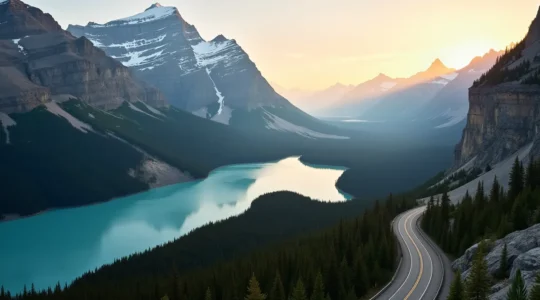
How to Visit Moraine Lake, Lake Louise, and the Icefields Parkway in a Single 14-Hour Day?
Completing this 14-hour Rockies triple-header is a logistical challenge, not a sightseeing tour; success is determined by precision and sequence, not ambition. Shuttle access to Moraine Lake is non-negotiable and requires mastering Parks Canada’s specific 48-hour rolling reservation window. Midday…
Read more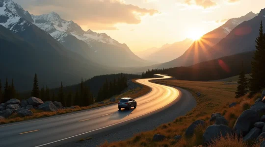
Icefields Parkway with 4 Hours of Daylight? A Mission-Critical Guide
Driving the Icefields Parkway late isn’t about seeing everything; it’s about seeing the right things before sunset. Prioritize three high-impact stops: Sunwapta Falls, Athabasca Falls, and the Goats and Glaciers Viewpoint. Acknowledge the 103 km fuel desert after the Icefield…
Read more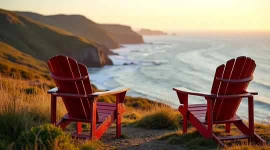
The Cabot Trail Red Chair Photo: A Tactical Guide to Ditching the Lineups
The best Cabot Trail red chair photo isn’t found by waiting in line; it’s created by strategically avoiding it. Identify “unofficial” photo ops with better views and no crowds, like community-placed chairs or natural rock ledges. Plan a “light-driven itinerary,”…
Read more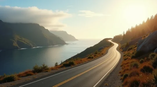
How to Drive the Entire Cabot Trail in One Day Without Rushing the Views?
Driving the Cabot Trail in a single day is achievable without feeling rushed, but it requires a strategy of logistical sequencing, not just speed. Direction Matters: A counter-clockwise route minimizes motion sickness and aligns you perfectly for optimal sunset photography…
Read more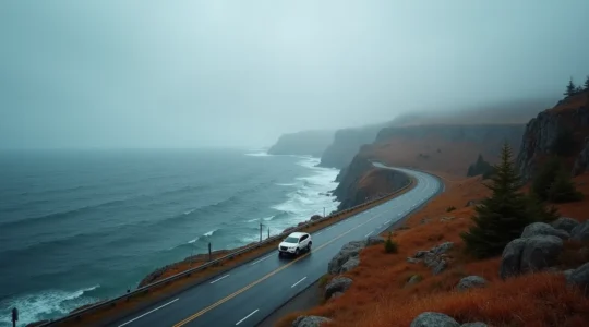
Can You Really Drive Newfoundland’s South Coast in October? An Honest Guide.
Contrary to common belief, an October road trip in Newfoundland isn’t a lesser version of a summer holiday—it’s a more authentic and rewarding adventure for the prepared traveler. Success hinges on proactive planning for “service gaps” (fuel, food) and volatile…
Read more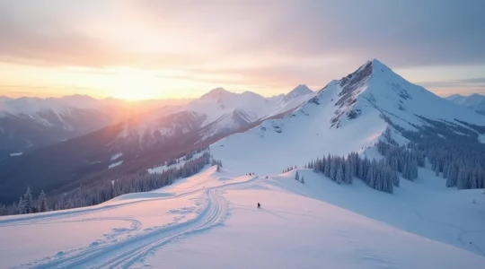
The Ikon Pass Holder’s Strategic Guide to Maximizing Whistler Days
Successfully using your Ikon Pass at Whistler is a logistical game of anticipating system friction and making strategic trade-offs, not just a ski trip. Blackout dates are just the start; the real barrier is the reservation system, which requires planning…
Read more
How to Buy an Epic Pass for Canada in CAD vs USD: Where is the Real Saving?
The true cost of a Canadian ski season is not the Epic Pass sticker price, but the ‘Total Cost of Access’ (TCA)—a metric factoring in hidden fees, equipment ROI, and risk. Purchasing in April can save over $400 CAD annually,…
Read more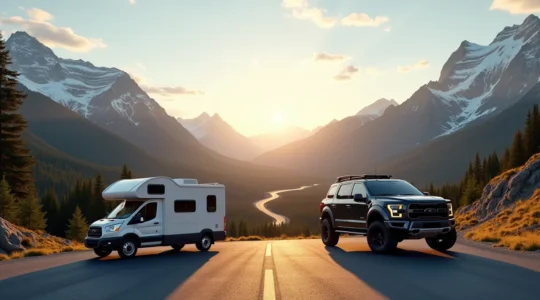
RV vs. Rental Car: The Definitive Logistical Guide to the Canadian Rockies
The best vehicle choice for the Canadian Rockies isn’t about freedom vs. cost; it’s determined by your family’s tolerance for logistical friction and hidden operational risks. An RV’s perceived flexibility is offset by a “mountain physics tax” on fuel and…
Read more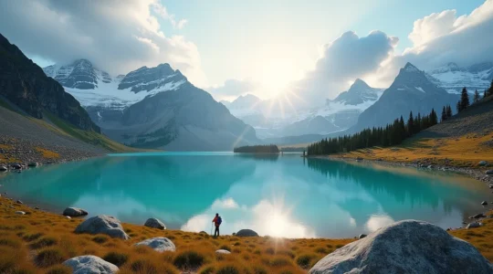
How to Choose a Guided Tour That Justifies the $200 Price Tag?
The $200 price on a guided tour isn’t a guarantee of quality; it’s a claim of value that demands scrutiny. Genuine value lies in verifiable elements like elite guide certifications (ACMG), exclusive access that bypasses public queues (like the Lake…
Read more